Species Details
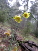
Fritillaria eastwoodiae
Butte County fritillary
Download Report Calflora eFlora CCH CalPhotos
©2009 Sierra Pacific Industries |

©2014 Sierra Pacific Industries |

©2015 John Doyen |
|
Scientific Name: Fritillaria eastwoodiae MacFarlane |
||
|
Common Name: Butte County fritillary |
||
| Family: | Liliaceae | |
| Element Code: | PMLIL0V060 | |
| USDA Plants Symbol: | FREA | |
|
Synonyms/Other Names: |
||
| CA Rare Plant Rank: | 3.2 |
| Fed List: | None |
| State List: | None |
| Global Rank: | G3Q |
|
State Rank: |
S3 |
| Other Status: | USFS_S |
|
CRPR Changes: changed from 3.2 to 3.2 on 2009-04-30 |
|
| Add Date: | 1974-01-01 |
| Date Edited: | 2022-01-05 |
| Lifeform: perennial bulbiferous herb | ||||||||||||||
Blooming Period: Mar-Jun
|
||||||||||||||
|
Elevation:
50 - 1500 meters 165 - 4920 feet |
||||||||||||||
General Habitats:
|
||||||||||||||
| Microhabitat Details: | ||||||||||||||
Microhabitat:
|
||||||||||||||
|
Notes: Move to List 1B? Plants from SHA and THE Co. may be different taxon; needs study. Occurrence on 608C needs confirmation. Threatened on private lands by logging and development. Other threats include vehicles, road maintenance, recreational activities, alteration of fire regimes, erosion, non-native plants and overshading. See Leaflets of Western Botany 1:55 (1933) for original description as F. phaeanthera, and Madroño 25(2):93-100 (1978) for revised nomenclature. |
|
|
Threats: Threatened on private lands by logging and development. Other threats include vehicles, road maintenance, recreational activities, alteration of fire regimes, erosion, non-native plants and overshading. |
|
|
Taxonomy: |
|
| Threat List Total: | 17 | |
| Total EOs | % of EOs | |
| EOs with Threat Listed: | 164 | 70 % |
| THREAT LIST: | ||
|---|---|---|
| Logging | 110 | 46% |
| Road/trail construction/maint. | 56 | 23% |
| Other | 27 | 11% |
| Recreational use (non-ORV) | 19 | 8% |
| Development | 14 | 5% |
| ORV activity | 11 | 4% |
| Improper burning regime | 10 | 4% |
| Erosion/runoff | 10 | 4% |
| Foot traffic/trampling | 8 | 3% |
| Mining | 7 | 2% |
| Grazing | 5 | 2% |
| Vandalism/dumping/litter | 5 | 2% |
| Agriculture | 4 | 1% |
| Biocides | 3 | 1% |
| Non-native plant impacts | 3 | 1% |
| Wood cutting or brush clearing | 2 | 0% |
| Disking | 1 | 0% |
| Total Occurrences: | 235 | ||||
| Element Occurrence Ranks: | |||||
|---|---|---|---|---|---|
| A | B | C | D | X | U |
| 14 | 86 | 41 | 19 | 1 | 74 |
| Occurrence Status: | |||||
|---|---|---|---|---|---|
| Historical >20 Years | 100 | ||||
| Recent <=20 Years | 135 | ||||
| Presence: | |||||
|---|---|---|---|---|---|
| Presumed Extant | 234 | ||||
| Possibly Extirpated | 1 | ||||
| Presumed Extirpated | 0 | ||||
| California Endemic: | |||||||||||||
| California Island: | |||||||||||||
|
States: Name (Code) California (CA), Oregon (OR) |
|||||||||||||
|
California Counties and Islands: Name (Code) Butte (BUT), El Dorado (ELD), Nevada (NEV), Placer (PLA), Shasta (SHA), Tehama (TEH), Yuba (YUB) |
|||||||||||||
|
Quads: Name (Quad Code) Auburn (3812181), Berry Creek (3912164), Bollibokka Mtn. (4012282), Brush Creek (3912163), Burney Falls (4112116), Cascade (3912162), Chalk Mtn. (4012187), Challenge (3912142), Cherokee (3912165), Chico (3912167), Clipper Mills (3912152), Cohasset (3912186), Devils Rock (4012271), Dewitt Peak (4012128), Finley Butte (4012137), Forbestown (3912153), Foresthill (3912017), French Corral (3912132), Goose Gap (4012281), Grays Peak (4012146), Greenwood (3812088), Hagaman Gulch (4012157), Hamlin Canyon (3912166), Inskip Hill (4012138), Inwood (4012158), Kimshew Point (3912184), Manton (4012147), Miller Mtn. (4012167), Minnesota Mtn. (4012272), Montgomery Creek (4012178), Nevada City (3912131), North Bloomfield (3912038), Oak Run (4012261), Oroville (3912155), Oroville Dam (3912154), Panther Spring (4012127), Paradise East (3912175), Paradise West (3912176), Pulga (3912174), Rackerby (3912143), Roaring Creek (4012188), Shingletown (4012148), Stirling City (3912185), Viola (4012156), Washington (3912037), Whitmore (4012168) |
|||||||||||||
Notes:
|
|||||||||||||
 Presumed Extant
Click on quad for name. Hold Shift Key to use mouse scroll wheel
| CNPS Status Review: | CRPR List Change on 2009-04-30 |
| Other: | USFS Potential Species of Conservation Concern Profile |