
© 2008 Steve Matson |

© 2019 Neal Kramer |
© 2008 Steve Matson |
|
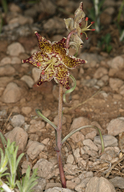
Scientific Name: Fritillaria pinetorum A. Davids. |
||
|
Common Name: pine fritillary |
||
| Family: | Liliaceae | |
| Element Code: | PMLIL0V0E0 | |
| USDA Plants Symbol: | FRPI | |
|
Synonyms/Other Names: |
||
| CA Rare Plant Rank: | 4.3 |
| Fed List: | None |
| State List: | None |
| Global Rank: | G4 |
|
State Rank: |
S4 |
| Other Status: | SB_CalBG/RSABG |
|
CRPR Changes: |
|
| Add Date: | 2001-01-01 |
| Date Edited: | 2022-01-05 |
| Lifeform: perennial bulbiferous herb | ||||||||||||||
Blooming Period: May-Jul(Sep)
|
||||||||||||||
|
Elevation:
1735 - 3300 meters 5695 - 10825 feet |
||||||||||||||
General Habitats:
|
||||||||||||||
| Microhabitat Details: | ||||||||||||||
Microhabitat:
|
||||||||||||||
| Threat List Total: | 0 | |
| Total EOs | % of EOs | |
| EOs with Threat Listed: | 0 | 0 % |
| THREAT LIST: | ||
|---|---|---|
| Total Occurrences: | 0 | ||||
| Element Occurrence Ranks: | |||||
|---|---|---|---|---|---|
| A | B | C | D | X | U |
| 0 | 0 | 0 | 0 | 0 | 0 |
| Occurrence Status: | |||||
|---|---|---|---|---|---|
| Historical >20 Years | 0 | ||||
| Recent <=20 Years | 0 | ||||
| Presence: | |||||
|---|---|---|---|---|---|
| Presumed Extant | 0 | ||||
| Possibly Extirpated | 0 | ||||
| Presumed Extirpated | 0 | ||||
| California Endemic: | |||||||||||||
| California Island: | |||||||||||||
|
States: Name (Code) California (CA) |
|||||||||||||
|
California Counties and Islands: Name (Code) Alpine (ALP)?, Inyo (INY), Kern (KRN), Los Angeles (LAX), Mono (MNO), San Bernardino (SBD), Tulare (TUL), Tuolumne (TUO), Ventura (VEN) |
|||||||||||||
|
Quads: Name (Quad Code) Alamo Mountain (3411868), Alta Sierra (3511865), Big Bear City (3411637), Big Bear Lake (3411628), Bloody Mtn. (3711858), Breckenridge Mtn. (3511845), Casa Vieja Meadows (3611823), Claraville (3511843), Convict Lake (3711857), Crag Peak (3611812), Crystal Crag (3711951), Crystal Lake (3411737), Cucamonga Peak (3411725), Cummings Mtn. (3511815), Emerald Mtn. (3511833), Fawnskin (3411638), Freel Peak (3811978), Harrison Mtn. (3411722), Johnsondale (3511885), June Lake (3711971), Kearsarge Peak (3611873), Lake Isabella South (3511854), Liebre Twins (3411885), Lockwood Valley (3411961), Mammoth Mtn. (3711961), Mescal Creek (3411746), Monolith (3511813), Moonridge (3411627), Moses Mtn. (3611836), Mount Dana (3711982), Mount San Antonio (3411736), Olancha (3611831), Old Mammoth (3711868), Onyx Peak (3411626), Owens Peak (3511768), Piute Peak (3511844), Reyes Peak (3411963), Sawmill Mountain (3411972), Sentinel Peak (3611815), Split Mtn. (3711814), Tehachapi North (3511824), Tehachapi South (3511814), Telegraph Peak (3411735), Tobias Peak (3511875), Tungsten Hills (3711835), Walker Pass (3511861) |
|||||||||||||
Notes:
|
|||||||||||||
 Presumed Extant
Click on quad for name. Hold Shift Key to use mouse scroll wheel