Taxon Details
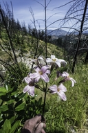
Lilium rubescens
redwood lily
View Report Copy Link Calflora eFlora CCH CalPhotos iNaturalist

Gerald and Buff Corsi © 2022 California Academy of Sciences |
Gerald and Buff Corsi © 2022 California Academy of Sciences |

© 2014 Aaron E. Sims and CNPS |
Taxon Summary:
Lilium rubescens, commonly known as redwood lily, is a perennial bulbiferous herb in the Liliaceae that is found only in California. It occurs within Broadleafed upland forest, Chaparral, Lower montane coniferous forest, North Coast coniferous forest, and Upper montane coniferous forest, growing at elevations from 30 to 1910 meters. Lilium rubescens is ranked 4.2, Plants of Limited Distribution, A Watch List; Moderately threatened in California.|
Scientific Name: Lilium rubescens Wats. |
||
|
Common Name: redwood lily |
||
| Family: | Liliaceae | |
| Element Code: | PMLIL1A0N0 | |
| USDA Plants Symbol: | LIRU | |
|
Synonyms/Other Names: |
||
| Name Status: |
JEF, FNA, POWO, IPNI, Tropicos |
|
| CA Rare Plant Rank: | 4.2 |
| Fed List: | None |
| State List: | None |
| Global Rank: | G3 |
|
State Rank: |
S3 |
| Other Status: | SB_CalBG/RSABG; SB_USDA |
|
CRPR Changes: |
|
| Add Date: | 1974-01-01 |
| Date Edited: | 2025-10-29 |
| Lifeform: perennial bulbiferous herb | ||||||||||||||
Blooming Period: (Mar)Apr-Aug(Sep)
|
||||||||||||||
|
Elevation:
30 - 1910 meters 100 - 6265 feet |
||||||||||||||
General Habitats:
|
||||||||||||||
| Microhabitat Details: | ||||||||||||||
Microhabitat:
|
||||||||||||||
| Threat List Total: | 0 | |
| Total EOs | % of EOs | |
| EOs with Threat Listed: | 0 | 0 % |
| THREAT LIST: | ||
|---|---|---|
| Total Occurrences: | 0 | ||||
| Element Occurrence Ranks: | |||||
|---|---|---|---|---|---|
| A | B | C | D | X | U |
| 0 | 0 | 0 | 0 | 0 | 0 |
| Occurrence Status: | |||||
|---|---|---|---|---|---|
| Historical >20 Years | 0 | ||||
| Recent <=20 Years | 0 | ||||
| Presence: | |||||
|---|---|---|---|---|---|
| Presumed Extant | 0 | ||||
| Possibly Extirpated | 0 | ||||
| Presumed Extirpated | 0 | ||||
| California Endemic: | |||||||||||||
| California Island: | |||||||||||||
|
States: Name (Code) California (CA) |
|||||||||||||
|
California Counties and Islands: Name (Code) Del Norte (DNT), Glenn (GLE), Humboldt (HUM), Lake (LAK), Mendocino (MEN), Napa (NAP), Shasta (SHA), Siskiyou (SIS), Sonoma (SON), Trinity (TRI) |
|||||||||||||
|
Quads: Name (Quad Code) Bailey Ridge (3912324), Bear Harbor (3912388), Blocksburg (4012336), Board Camp Mtn. (4012366), Bridgeville (4012347), Bull Creek (4012431), Bully Choop Mtn. (4012257), Burbeck (3912344), Cahto Peak (3912365), Calistoga (3812255), Carrville (4112216), Chanchelulla Peak (4012248), Chicken Hawk Hill (4112214), Cold Spring (3912315), Comptche (3912335), Covington Mill (4012287), Damnation Peak (4012285), Dinsmore (4012345), Dunsmuir (4112223), Dutchmans Knoll (3912356), Fish Lake (4112336), Hales Grove (3912377), Halfway Ridge (4012353), Hayfork Summit (4012351), Hyampom (4012354), Hydesville (4012451), Iaqua Buttes (4012368), Johnsons (4112337), Junction City (4012361), Kenwood (3812245), Larabee Valley (4012346), Leggett (3912376), Lincoln Ridge (3912366), Longvale (3912354), Lord-ellis Summit (4012387), Mad River Buttes (4012367), Mark West Springs (3812256), McWhinney Creek (4012461), Miranda (4012327), Mistake Point (3912378), Mt. George (3812232), Mumbo Basin (4112225), Myers Flat (4012337), Naufus Creek (4012343), Navarro (3912325), Noble Butte (3912386), Northspur (3912345), Noyo Hill (3912346), Orrs Springs (3912323), Owl Creek (4012358), Papoose Creek (4012276), Philo (3912314), Piercy (3912387), Plaskett Meadows (3912267), Polar Bear Mtn. (4112385), Purdys Gardens (3912311), Redcrest (4012348), Sawyers Bar (4112332), Schell Mtn. (4012275), Scotia (4012441), Seven Lakes Basin (4112224), Sherwood Peak (3912355), Siligo Peak (4012288), Sonoma (3812234), Sportshaven (4012344), Taylor Peak (4012442), The Geysers (3812277), Tombstone Mtn. (4112213), Trinity Center (4012286), Trinity Dam (4012277), Ukiah (3912322), Weitchpec (4112326), Weott (4012338), Westport (3912367), Whisky Bill Peak (4112215), Whispering Pines (3812276), Wildwood (4012341), Yager Junction (4012357), Ycatapom Peak (4112217), Yorkville (3812382) |
|||||||||||||
Notes:
|
|||||||||||||
 Presumed Extant
Click on quad for name. Hold Shift Key to use mouse scroll wheel