Taxon Details
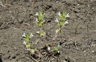
Acanthomintha obovata ssp. obovata
San Benito thorn-mint
View Report Copy Link Calflora eFlora CCH CalPhotos iNaturalist

© 2013 Chris Winchell |
© 2013 Chris Winchell |

© 2013 Chris Winchell |
Taxon Summary:
Acanthomintha obovata ssp. obovata, commonly known as San Benito thorn-mint, is a annual herb in the Lamiaceae that is found only in California. It occurs within Chaparral, Cismontane woodland, and Valley and foothill grassland, growing at elevations from 395 to 1500 meters. Acanthomintha obovata ssp. obovata is ranked 4.2, Plants of Limited Distribution, A Watch List; Moderately threatened in California.|
Scientific Name: Acanthomintha obovata Jeps. ssp. obovata |
||
|
Common Name: San Benito thorn-mint |
||
| Family: | Lamiaceae | |
| Element Code: | PDLAM01032 | |
| USDA Plants Symbol: | ACOBO | |
|
Synonyms/Other Names: |
||
| Name Status: |
JEF, FNA, POWO, IPNI, Tropicos |
|
| CA Rare Plant Rank: | 4.2 |
| Fed List: | None |
| State List: | None |
| Global Rank: | G4T3T4 |
|
State Rank: |
S3S4 |
| Other Status: | |
|
CRPR Changes: |
|
| Add Date: | 1974-01-01 |
| Date Edited: | 2025-10-29 |
| Lifeform: annual herb | ||||||||||||||
Blooming Period: Apr-Jul
|
||||||||||||||
|
Elevation:
395 - 1500 meters 1295 - 4920 feet |
||||||||||||||
General Habitats:
|
||||||||||||||
| Microhabitat Details: heavy clay | ||||||||||||||
Microhabitat:
|
||||||||||||||
| Threat List Total: | 0 | |
| Total EOs | % of EOs | |
| EOs with Threat Listed: | 0 | 0 % |
| THREAT LIST: | ||
|---|---|---|
| Total Occurrences: | 0 | ||||
| Element Occurrence Ranks: | |||||
|---|---|---|---|---|---|
| A | B | C | D | X | U |
| 0 | 0 | 0 | 0 | 0 | 0 |
| Occurrence Status: | |||||
|---|---|---|---|---|---|
| Historical >20 Years | 0 | ||||
| Recent <=20 Years | 0 | ||||
| Presence: | |||||
|---|---|---|---|---|---|
| Presumed Extant | 0 | ||||
| Possibly Extirpated | 0 | ||||
| Presumed Extirpated | 0 | ||||
| California Endemic: | |||||||||||||
| California Island: | |||||||||||||
|
States: Name (Code) California (CA) |
|||||||||||||
|
California Counties and Islands: Name (Code) Fresno (FRE), Monterey (MNT), San Benito (SBT) |
|||||||||||||
|
Quads: Name (Quad Code) Ciervo Mtn. (3612045), Cosio Knob (3612112), Curry Mountain (3612014), Hepsedam Peak (3612037), Hernandez Reservoir (3612047), Joaquin Rocks (3612034), Lonoak (3612038), Monarch Peak (3612027), Parkfield (3512084), Pinalito Canyon (3612131), Priest Valley (3612026), Rock Spring Peak (3612048), San Benito (3612151), San Benito Mtn. (3612036), The Dark Hole (3512083) |
|||||||||||||
Notes:
|
|||||||||||||
 Presumed Extant
Click on quad for name. Hold Shift Key to use mouse scroll wheel