Taxon Details
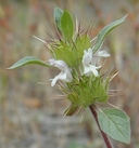
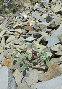
Acanthomintha lanceolata
Santa Clara thorn-mint
View Report Copy Link Calflora eFlora CCH CalPhotos iNaturalist
© 2005 Barry Breckling |

© 2009 Barry Breckling |
© 2016 Neal Kramer |
Taxon Summary:
Acanthomintha lanceolata, commonly known as Santa Clara thorn-mint, is a annual herb in the Lamiaceae that is found only in California. It occurs within Chaparral (often serpentine), Cismontane woodland, and Coastal scrub, growing at elevations from 80 to 1200 meters. Acanthomintha lanceolata is ranked 4.2, Plants of Limited Distribution, A Watch List; Moderately threatened in California.|
Scientific Name: Acanthomintha lanceolata Curran |
||
|
Common Name: Santa Clara thorn-mint |
||
| Family: | Lamiaceae | |
| Element Code: | PDLAM01020 | |
| USDA Plants Symbol: | ACLA2 | |
|
Synonyms/Other Names: |
||
| Name Status: |
JEF, FNA, POWO, IPNI, Tropicos |
|
| CA Rare Plant Rank: | 4.2 |
| Fed List: | None |
| State List: | None |
| Global Rank: | G4 |
|
State Rank: |
S4 |
| Other Status: | SB_CalBG/RSABG |
|
CRPR Changes: |
|
| Add Date: | 1974-01-01 |
| Date Edited: | 2025-10-29 |
| Lifeform: annual herb | ||||||||||||||
Blooming Period: Mar-Jun
|
||||||||||||||
|
Elevation:
80 - 1200 meters 260 - 3935 feet |
||||||||||||||
General Habitats:
|
||||||||||||||
| Microhabitat Details: | ||||||||||||||
Microhabitat:
|
||||||||||||||
| Threat List Total: | 0 | |
| Total EOs | % of EOs | |
| EOs with Threat Listed: | 0 | 0 % |
| THREAT LIST: | ||
|---|---|---|
| Total Occurrences: | 0 | ||||
| Element Occurrence Ranks: | |||||
|---|---|---|---|---|---|
| A | B | C | D | X | U |
| 0 | 0 | 0 | 0 | 0 | 0 |
| Occurrence Status: | |||||
|---|---|---|---|---|---|
| Historical >20 Years | 0 | ||||
| Recent <=20 Years | 0 | ||||
| Presence: | |||||
|---|---|---|---|---|---|
| Presumed Extant | 0 | ||||
| Possibly Extirpated | 0 | ||||
| Presumed Extirpated | 0 | ||||
| California Endemic: | |||||||||||||
| California Island: | |||||||||||||
|
States: Name (Code) California (CA) |
|||||||||||||
|
California Counties and Islands: Name (Code) Alameda (ALA), Fresno (FRE), Merced (MER), Monterey (MNT), San Benito (SBT), San Joaquin (SJQ), Santa Clara (SCL), Stanislaus (STA) |
|||||||||||||
|
Quads: Name (Quad Code) Calaveras Reservoir (3712147), Cedar Mtn. (3712155), Cerro Colorado (3612068), Copper Mtn. (3712143), Curry Mountain (3612014), Eylar Mtn. (3712145), Gilroy (3712115), Hepsedam Peak (3612037), Hernandez Reservoir (3612047), Idria (3612046), Isabel Valley (3712135), La Costa Valley (3712157), Lick Observatory (3712136), Llanada (3612058), Lone Tree Creek (3712154), Los Banos Valley (3612181), Mariposa Peak (3612182), Midway (3712165), Mississippi Creek (3712124), Monarch Peak (3612027), Mt. Boardman (3712144), Mt. Day (3712146), Mt. Sizer (3712125), Mt. Stakes (3712134), Ortigalita Peak (3612078), Pacheco Pass (3712112), Rock Spring Peak (3612048), Ruby Canyon (3612171), San Benito Mtn. (3612036), Santa Rita Peak (3612035), Solyo (3712153), Wilcox Ridge (3712133) |
|||||||||||||
Notes:
|
|||||||||||||
 Presumed Extant
Click on quad for name. Hold Shift Key to use mouse scroll wheel