Taxon Details
Cypripedium fasciculatum
clustered lady's-slipper
View Report Copy Link Calflora eFlora CCH CalPhotos iNaturalist
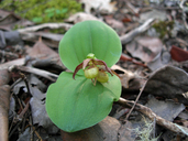
© 2013 Scot Loring |
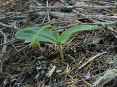
©2021 Scot Loring |

© 2021 Scot Loring |
Taxon Summary:
Cypripedium fasciculatum, commonly known as clustered lady's-slipper, is a perennial rhizomatous herb in the Orchidaceae that is found in California and elsewhere. It occurs within Lower montane coniferous forest, and North Coast coniferous forest, growing at elevations from 100 to 2435 meters. Cypripedium fasciculatum is ranked 4.2, Plants of Limited Distribution, A Watch List; Moderately threatened in California.|
Scientific Name: Cypripedium fasciculatum Wats. |
||
|
Common Name: clustered lady's-slipper |
||
| Family: | Orchidaceae | |
| Element Code: | PMORC0Q060 | |
| USDA Plants Symbol: | CYFA | |
|
Synonyms/Other Names: |
||
| Name Status: |
JEF, FNA, POWO, IPNI, Tropicos |
|
| CA Rare Plant Rank: | 4.2 |
| Fed List: | None |
| State List: | None |
| Global Rank: | G4 |
|
State Rank: |
S4 |
| Other Status: | IUCN_VU; USFS_S |
|
CRPR Changes: |
|
| Add Date: | 1980-01-01 |
| Date Edited: | 2025-10-29 |
| Lifeform: perennial rhizomatous herb | ||||||||||||||
Blooming Period: Mar-Aug
|
||||||||||||||
|
Elevation:
100 - 2435 meters 330 - 7990 feet |
||||||||||||||
General Habitats:
|
||||||||||||||
| Microhabitat Details: | ||||||||||||||
Microhabitat:
|
||||||||||||||
|
Notes: Widely scattered, but most occurrences small. Not seen recently in SCL or SMT counties. Threatened by logging and horticultural collecting. Monitoring needed for protected populations on USFS lands to assess reproduction, which may be inadequate. Threatened in ID, candidate for state listing in OR, and state-listed as Threatened in WA. See Proceedings of the American Academy of Arts and Sciences 17:380 (1882) for original description, Lindleyana 2(1):553-57 (1987) for distributional information, and Fremontia 17(2):17-19 (1989) and The Wild Orchids of California, p. 65-68 (1995) by R. Coleman for species accounts. |
|
|
Threats: |
|
|
Taxonomy: |
|
| Threat List Total: | 0 | |
| Total EOs | % of EOs | |
| EOs with Threat Listed: | 0 | 0 % |
| THREAT LIST: | ||
|---|---|---|
| Total Occurrences: | 0 | ||||
| Element Occurrence Ranks: | |||||
|---|---|---|---|---|---|
| A | B | C | D | X | U |
| 0 | 0 | 0 | 0 | 0 | 0 |
| Occurrence Status: | |||||
|---|---|---|---|---|---|
| Historical >20 Years | 0 | ||||
| Recent <=20 Years | 0 | ||||
| Presence: | |||||
|---|---|---|---|---|---|
| Presumed Extant | 0 | ||||
| Possibly Extirpated | 0 | ||||
| Presumed Extirpated | 0 | ||||
| California Endemic: | |||||||||||||
| California Island: | |||||||||||||
|
States: Name (Code) California (CA), Colorado (CO), Idaho (ID), Montana (MT), Oregon (OR), Utah (UT), Washington (WA), Wyoming (WY) |
|||||||||||||
|
California Counties and Islands: Name (Code) Butte (BUT), Del Norte (DNT), Glenn (GLE), Humboldt (HUM), Lassen (LAS), Mendocino (MEN), Nevada (NEV), Plumas (PLU), San Mateo (SMT), Santa Clara (SCL), Santa Cruz (SCR)*, Shasta (SHA), Sierra (SIE), Siskiyou (SIS), Tehama (TEH), Trinity (TRI), Yuba (YUB) |
|||||||||||||
|
Quads: Name (Quad Code) Squaw Lakes (4212311), Almanor (4012122), American House (3912161), Belden (4012113), Berry Creek (3912164), Big Bar (4012363), Big Basin (3712222), Black Rock Mtn. (4012321), Blake Mountain (4012355), Broken Rib Mtn. (4112386), Brush Creek (3912163), Buck Rock (3912288), Buckhorn Bally (4112287), Bucks Lake (3912182), Camptonville (3912141), Canyondam (4012121), Caribou (4012112), Caribou Lake (4112218), Carrville (4112216), Cascade (3912162), Cecil Lake (4112312), Cecilville (4112322), Chimney Rock (4112356), City of Mount Shasta (4112233), Clear Creek (4112364), Clipper Mills (3912152), Cottonwood Peak (4112286), Covington Mill (4012287), Crescent Mills (4012018), Cupertino (3712231), Damnation Peak (4012285), Deadman Point (4112384), Denny (4012384), Dillon Mtn. (4112355), Dinsmore (4012345), Dogwood Peak (3912171), Downieville (3912057), Dubakella Mtn. (4012342), Dutch Creek (4112381), Eaton Peak (4112238), English Peak (4112342), Etna (4112248), French Gulch (4012266), Goodyears Bar (3912058), Graniteville (3912046), Grasshopper Ridge (4112321), Greenville (4012028), Grider Valley (4112362), Halfway Ridge (4012353), Hamburg (4112371), Happy Camp (4112374), Haskins Valley (3912172), Hayfork (4012352), Hayfork Bally (4012362), Hayfork Summit (4012351), Haypress Valley (3912055), Hoosimbim Mtn. (4012258), Hopkins Butte (4112325), Horse Creek (4112278), Hotlum (4112243), Huckleberry Mtn. (4112363), Indian Creek Baldy (4112267), Kangaroo Mtn. (4112382), La Porte (3912068), Larabee Valley (4012346), Laurel (3712118), Leech Lake Mtn. (3912381), Lewiston (4012267), Log Spring (3912277), Loma Prieta (3712117), Marble Mountain (4112352), McKinley Mtn. (4112277), Meadow Valley (3912181), Mendocino Pass (3912278), Mindego Hill (3712232), Montara Mountain (3712254), Mount Eddy (4112234), Nevada City (3912131), North Bloomfield (3912038), North Yolla Bolly (4012228), Onion Valley (3912078), Papoose Creek (4012276), Paradise East (3912175), Plaskett Meadows (3912267), Plaskett Ridge (3912268), Platina (4012238), Pony Buck Peak (4012331), Preston Peak (4112375), Pulga (3912174), Quincy (3912088), Rush Creek Lakes (4012278), Salmon Mtn. (4112324), Sawyers Bar (4112332), Schell Mtn. (4012275), Scott Bar (4112361), Scott Mountain (4112236), Seiad Valley (4112372), Seven Lakes Basin (4112224), Shannon Butte (4012323), Shasta Bally (4012256), Shelly Creek Ridge (4112387), Slater Butte (4112373), Soapstone Hill (3912173), Solomon Peak (4012218), Somes Bar (4112344), South Yolla Bolly (4012217), Sportshaven (4012344), Stirling City (3912185), Storrie (3912183), Strawberry Valley (3912151), Swim Ridge (4012322), Tanners Peak (4112331), Thompson Peak (4112311), Tombstone Mtn. (4112213), Tomhead Mtn. (4012227), Trinity Center (4012286), Trinity Dam (4012277), Twain (4012111), Ukonom Mtn. (4112354), Washington (3912037), Weaverville (4012268), Weed (4112244), Weitchpec (4112326), Westwood West (4012131), Whisky Bill Peak (4112215), Wildwood (4012341), Woodside (3712243), Ycatapom Peak (4112217), Yellow Dog Peak (4112341), Zenia (4012324) |
|||||||||||||
Notes:
|
|||||||||||||
 Presumed Extant
Click on quad for name. Hold Shift Key to use mouse scroll wheel