Species Details
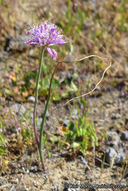
Allium howellii var. howellii
Howell's onion
Download Report Calflora eFlora CCH CalPhotos

© 2013 Neal Kramer |
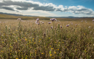
© 2016 Keir Morse |
© 2020 Chris Winchell |
|
Scientific Name: Allium howellii Eastw. var. howellii |
||
|
Common Name: Howell's onion |
||
| Family: | Alliaceae | |
| Element Code: | PMLIL02162 | |
| USDA Plants Symbol: | ALHOH | |
|
Synonyms/Other Names: |
||
| CA Rare Plant Rank: | 4.3 |
| Fed List: | None |
| State List: | None |
| Global Rank: | G3G4T3 |
|
State Rank: |
S3 |
| Other Status: | |
|
CRPR Changes: added to 4.3 on 2017-04-04 |
|
| Add Date: | 2017-04-04 |
| Date Edited: | 2024-03-06 |
| Lifeform: perennial bulbiferous herb | ||||||||||||||
Blooming Period: Mar-Apr
|
||||||||||||||
|
Elevation:
50 - 2200 meters 165 - 7220 feet |
||||||||||||||
General Habitats:
|
||||||||||||||
| Microhabitat Details: | ||||||||||||||
Microhabitat:
|
||||||||||||||
| Threat List Total: | 0 | |
| Total EOs | % of EOs | |
| EOs with Threat Listed: | 0 | 0 % |
| THREAT LIST: | ||
|---|---|---|
| Total Occurrences: | 0 | ||||
| Element Occurrence Ranks: | |||||
|---|---|---|---|---|---|
| A | B | C | D | X | U |
| 0 | 0 | 0 | 0 | 0 | 0 |
| Occurrence Status: | |||||
|---|---|---|---|---|---|
| Historical >20 Years | 0 | ||||
| Recent <=20 Years | 0 | ||||
| Presence: | |||||
|---|---|---|---|---|---|
| Presumed Extant | 0 | ||||
| Possibly Extirpated | 0 | ||||
| Presumed Extirpated | 0 | ||||
| California Endemic: | |||||||||||||
| California Island: | |||||||||||||
|
States: Name (Code) California (CA) |
|||||||||||||
|
California Counties and Islands: Name (Code) Fresno (FRE), Kern (KRN), Merced (MER), San Benito (SBT), San Luis Obispo (SLO), Santa Clara (SCL), Tulare (TUL) |
|||||||||||||
|
Quads: Name (Quad Code) Alta Sierra (3511865), Ballinger Canyon (3411984), Bena (3511836), Breckenridge Mtn. (3511845), Caliente Mtn. (3511917), California Valley (3512031), Cerro Colorado (3612068), Chimineas Ranch (3511928), Delano West (3511973), Democrat Hot Springs (3511856), Edison (3511837), Elkhorn Hills (3511915), Fellows (3511925), Hammonds Ranch (3612076), Hepsedam Peak (3612037), Keene (3511825), Knob Hill (3511858), Lake Isabella North (3511864), Maricopa (3511914), McKittrick Summit (3511937), Mercey Hot Springs (3612067), Monolith (3511813), Oil Center (3511848), Oiler Peak (3511835), Ortigalita Peak (3612078), Packwood Creek (3512051), Painted Rock (3511927), Panoche (3612057), Panoche Pass (3612161), Panorama Hills (3511926), Pentland (3511913), Pine Mountain (3511857), Pozo Summit (3512033), Rio Bravo Ranch (3511847), San Felipe (3612184), Sand Canyon (3511868), Santa Margarita Lake (3512034), Shale Point (3511958), Simmler (3511938), Tehachapi NE (3511823), Tehachapi North (3511824), Tehachapi South (3511814), Tejon Hills (3511817), Tent Hills (3512072), The Dark Hole (3512083), Wells Ranch (3511916), White River (3511877), Woody (3511867) |
|||||||||||||
Notes:
|
|||||||||||||
 Presumed Extant
Click on quad for name. Hold Shift Key to use mouse scroll wheel
| CNPS Status Review: | Proposed Addition to CRPR 4.3, G3G4T3 / S3 (2017) |
| Original Description: | Leaflets of Western Botany 2(7):109 (1938) |