Taxon Details
Allium abramsii
Abrams' onion
View Report Copy Link Calflora eFlora CCH CalPhotos iNaturalist

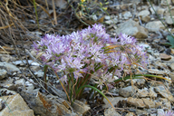
© 2018 Steve Matson |
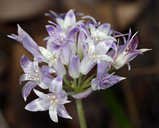
© 2016 Debra L. Cook |
© 2018 Steve Matson |
Taxon Summary:
Allium abramsii, commonly known as Abrams' onion, is a perennial bulbiferous herb in the Alliaceae that is found only in California. It occurs within Lower montane coniferous forest, and Upper montane coniferous forest, growing at elevations from 885 to 3050 meters. Allium abramsii is ranked 1B.2, Plants Rare, Threatened or Endangered in California and Elsewhere; Moderately threatened in California.|
Scientific Name: Allium abramsii (Ownbey & Aase ex Traub) McNeal |
||
|
Common Name: Abrams' onion |
||
| Family: | Alliaceae | |
| Element Code: | PMLIL02360 | |
| USDA Plants Symbol: | ALAB2 | |
|
Synonyms/Other Names: |
||
| Name Status: |
JEF, FNA, POWO, IPNI, Tropicos |
|
| CA Rare Plant Rank: | 1B.2 |
| Fed List: | None |
| State List: | None |
| Global Rank: | G3 |
|
State Rank: |
S3 |
| Other Status: | SB_SBBG |
|
CRPR Changes: added to 1B.2 on 2012-03-13 |
|
| Add Date: | 2012-03-13 |
| Date Edited: | 2025-10-29 |
| Lifeform: perennial bulbiferous herb | ||||||||||||||
Blooming Period: May-Jul
|
||||||||||||||
|
Elevation:
885 - 3050 meters 2905 - 10005 feet |
||||||||||||||
General Habitats:
|
||||||||||||||
| Microhabitat Details: Often granitic sand | ||||||||||||||
Microhabitat:
|
||||||||||||||
|
Notes: Plants from the Kings River Canyon area are threatened by foot traffic, and potentially threatened by road maintenance and mining. See Plant Life 28:63-64 (1972) for original description, and Aliso 13(3):411-426 (1992) for taxonomic treatment. |
|
|
Threats: Plants from the Kings River Canyon area are threatened by foot traffic, and potentially threatened by road maintenance and mining. |
|
|
Taxonomy: |
|
| Threat List Total: | 1 | |
| Total EOs | % of EOs | |
| EOs with Threat Listed: | 1 | 5 % |
| THREAT LIST: | ||
|---|---|---|
| Foot traffic/trampling | 1 | 4% |
| Total Occurrences: | 22 | ||||
| Element Occurrence Ranks: | |||||
|---|---|---|---|---|---|
| A | B | C | D | X | U |
| 0 | 0 | 1 | 0 | 0 | 21 |
| Occurrence Status: | |||||
|---|---|---|---|---|---|
| Historical >20 Years | 16 | ||||
| Recent <=20 Years | 6 | ||||
| Presence: | |||||
|---|---|---|---|---|---|
| Presumed Extant | 22 | ||||
| Possibly Extirpated | 0 | ||||
| Presumed Extirpated | 0 | ||||
| California Endemic: | |||||||||||||
| California Island: | |||||||||||||
|
States: Name (Code) California (CA) |
|||||||||||||
|
California Counties and Islands: Name (Code) Fresno (FRE), Madera (MAD), Tulare (TUL) |
|||||||||||||
|
Quads: Name (Quad Code) Auberry (3711914), Bass Lake (3711935), Cascadel Point (3711924), Case Mountain (3611847), Dinkey Creek (3711912), Durrwood Creek (3611814), Florence Lake (3711838), Globe (3611817), Hockett Peak (3611824), Huntington Lake (3711922), Lodgepole (3611856), Mammoth Pool Dam (3711933), Mineral King (3611845), Moses Mtn. (3611836), Mt. Givens (3711931), Mt. Silliman (3611866), Muir Grove (3611867), Musick Mtn. (3711923), Shuteye Peak (3711934), Silver City (3611846), Solo Peak (3611816), Ward Mountain (3711828), Wren Peak (3611877) |
|||||||||||||
Notes:
|
|||||||||||||
 Presumed Extant
Click on quad for name. Hold Shift Key to use mouse scroll wheel