Taxon Details
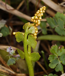
Botrychium crenulatum
scalloped moonwort
View Report Copy Link Calflora eFlora CCH CalPhotos iNaturalist
© 2016 Steve Matson |

© 2011 Aaron E. Sims |

© 2016 Aaron Schusteff |
Taxon Summary:
Botrychium crenulatum, commonly known as scalloped moonwort, is a perennial rhizomatous herb in the Ophioglossaceae that is found in California and elsewhere. It occurs within Bogs and fens, Lower montane coniferous forest, Marshes and swamps (freshwater), Meadows and seeps, and Upper montane coniferous forest, growing at elevations from 1268 to 3280 meters. Botrychium crenulatum is ranked 2B.2, Plants Rare, Threatened, or Endangered in California, But More Common Elsewhere; Moderately threatened in California.|
Scientific Name: Botrychium crenulatum W. Wagner |
||
|
Common Name: scalloped moonwort |
||
| Family: | Ophioglossaceae | |
| Element Code: | PPOPH010L0 | |
| USDA Plants Symbol: | BOCR | |
|
Synonyms/Other Names: |
||
| Name Status: |
JEF, FNA, POWO, IPNI, Tropicos |
|
| CA Rare Plant Rank: | 2B.2 |
| Fed List: | None |
| State List: | None |
| Global Rank: | G4 |
|
State Rank: |
S3 |
| Other Status: | USFS_S |
|
CRPR Changes: |
|
| Add Date: | 1984-01-01 |
| Date Edited: | 2026-02-03 |
| Lifeform: perennial rhizomatous herb | ||||||||||||||
Blooming Period: Jun-Sep
|
||||||||||||||
|
Elevation:
1268 - 3280 meters 4160 - 10760 feet |
||||||||||||||
General Habitats:
|
||||||||||||||
| Microhabitat Details: | ||||||||||||||
|
Microhabitat:
|
||||||||||||||
|
Notes: Scattered but not common anywhere in CA. On watch list in NV, candidate for state listing in OR, and state-listed as Sensitive in WA. See Madroño 36(2):131-136 (1989) for distributional information. |
|
|
Threats: Threatened by foot traffic, grazing, trampling, recreational activities, fuel reduction projects, and road deconstruction. Possibly threatened by logging and hydrological alterations. |
|
|
Taxonomy: See American Fern Journal 71(1):21 (1981) for original description. |
|
| Threat List Total: | 12 | |
| Total EOs | % of EOs | |
| EOs with Threat Listed: | 80 | 52 % |
| THREAT LIST: | ||
|---|---|---|
| Logging | 32 | 20% |
| Grazing | 28 | 18% |
| Foot traffic/trampling | 18 | 11% |
| Other | 16 | 10% |
| Road/trail construction/maint. | 12 | 7% |
| Recreational use (non-ORV) | 8 | 5% |
| Altered flood/tidal/hydrologic regime | 7 | 4% |
| Erosion/runoff | 6 | 3% |
| ORV activity | 4 | 2% |
| Improper burning regime | 2 | 1% |
| Wood cutting or brush clearing | 2 | 1% |
| Groundwater pumping | 1 | 0% |
| Total Occurrences: | 155 | ||||
| Element Occurrence Ranks: | |||||
|---|---|---|---|---|---|
| A | B | C | D | X | U |
| 9 | 40 | 33 | 8 | 0 | 65 |
| Occurrence Status: | |||||
|---|---|---|---|---|---|
| Historical >20 Years | 42 | ||||
| Recent <=20 Years | 113 | ||||
| Presence: | |||||
|---|---|---|---|---|---|
| Presumed Extant | 155 | ||||
| Possibly Extirpated | 0 | ||||
| Presumed Extirpated | 0 | ||||
| California Endemic: | |||||||||||||
| California Island: | |||||||||||||
|
States: Name (Code) Arizona (AZ), California (CA), Idaho (ID), Montana (MT), Nevada (NV), Oregon (OR), Utah (UT), Washington (WA), Wyoming (WY) |
|||||||||||||
|
California Counties and Islands: Name (Code) Alpine (ALP), Amador (AMA), Butte (BUT), Calaveras (CAL), Colusa (COL), El Dorado (ELD), Fresno (FRE), Inyo (INY), Lassen (LAS), Los Angeles (LAX), Modoc (MOD), Mono (MNO), Nevada (NEV), Placer (PLA), Plumas (PLU), San Bernardino (SBD), Shasta (SHA), Sierra (SIE), Siskiyou (SIS), Tehama (TEH), Trinity (TRI), Tulare (TUL), Tuolumne (TUO) |
|||||||||||||
|
Quads: Name (Quad Code) Ash Creek Butte (4112241), Bear River Reservoir (3812052), Big Bear Lake (3411628), Blairsden (3912075), Blanco Mtn. (3711842), Bloody Mtn. (3711858), Boards Crossing (3812032), Butte Meadows (4012115), Calaveras Dome (3812042), Caldor (3812054), Casa Vieja Meadows (3611823), Cherry Lake North (3811918), Chicken Hawk Hill (4112214), Cisco Grove (3912035), Convict Lake (3711857), Covington Mill (4012287), Coyote Flat (3711824), Crocker Mtn. (3912084), Crooked Creek (3711841), Crystal Lake (3411737), Dardanelles Cone (3811947), Davis Creek (4112063), Dogtooth Peak (3711921), Eagle Peak (4112032), Emerald Bay (3812081), English Mtn. (3912045), Forest Falls (3411618), Fouts Springs (3912236), Gallatin Peak (4012056), Grays Peak (4012146), Hatchet Mtn. Pass (4012177), Hobart Mills (3912042), Homewood (3912012), Hull Creek (3812011), Humboldt Peak (4012124), Humbug Valley (4012123), Independence Lake (3912043), Jacks Backbone (4012166), Jonesville (4012114), Kaiser Peak (3711932), Kimshew Point (3912184), Kyburz (3812073), Lassen Peak (4012145), Leek Spring Hill (3812063), Loon Lake (3812083), Meeks Bay (3912011), Miller Mtn. (4012167), Mineral (4012135), Monache Mountain (3611822), Moonridge (3411627), Mount Dana (3711982), Mount San Antonio (3411736), Mt. Barcroft (3711852), Mt. Bidwell (4112082), Mt. Fillmore (3912067), Mt. Harkness (4012143), Mt. Morgan (3711846), Mt. Patterson (3811943), Mumbo Basin (4112225), Norden (3912033), Onyx Peak (3411626), Peddler Hill (3812053), Pegleg Mtn. (4012048), Red Cinder (4012142), Robbs Peak (3812084), Rockbound Valley (3812082), Roop Mountain (4012047), San Gorgonio Mtn. (3411617), Sattley (3912054), Seven Lakes Basin (4112224), Shields Creek (4112043), Skunk Ridge (4112117), Soapstone Hill (3912173), Soup Creek (4112033), South Lake Tahoe (3811988), Station Peak (3711851), Susanville (4012046), Sweetwater Creek (3811942), Tahoe City (3912022), Telegraph Peak (3411735), Templeton Mtn. (3611832), Tioga Pass (3711983), Tragedy Spring (3812062), Viola (4012156), Warren Peak (4112042), West Haight Mtn. (4112251), Westwood East (4012038), Westwood West (4012131), Willow Ranch (4112083) |
|||||||||||||
Notes:
|
|||||||||||||
 Presumed Extant
Click on quad for name. Hold Shift Key to use mouse scroll wheel