Taxon Details
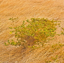
Centromadia parryi ssp. rudis
Parry's rough tarplant
View Report Copy Link Calflora eFlora CCH CalPhotos iNaturalist
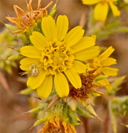
© 2019 John Doyen |
© 2019 John Doyen |

© 2015 Chris Winchell |
Taxon Summary:
Centromadia parryi ssp. rudis, commonly known as Parry's rough tarplant, is a annual herb in the Asteraceae that is found only in California. It occurs within Valley and foothill grassland, and Vernal pools, growing at elevations from 0 to 100 meters. Centromadia parryi ssp. rudis is ranked 4.2, Plants of Limited Distribution, A Watch List; Moderately threatened in California.|
Scientific Name: Centromadia parryi (Greene) Greene ssp. rudis (Greene) B.G. Baldwin |
||
|
Common Name: Parry's rough tarplant |
||
| Family: | Asteraceae | |
| Element Code: | PDAST4R0P3 | |
| USDA Plants Symbol: | CEPAR4 | |
|
Synonyms/Other Names: |
||
| Name Status: |
JEF, FNA, POWO, IPNI, Tropicos |
|
| CA Rare Plant Rank: | 4.2 |
| Fed List: | None |
| State List: | None |
| Global Rank: | G3T3 |
|
State Rank: |
S3 |
| Other Status: | |
|
CRPR Changes: added to 4.2 on 2007-05-22 |
|
| Add Date: | 2007-05-22 |
| Date Edited: | 2025-10-29 |
| Lifeform: annual herb | ||||||||||||||
Blooming Period: May-Oct
|
||||||||||||||
|
Elevation:
0 - 100 meters 0 - 330 feet |
||||||||||||||
General Habitats:
|
||||||||||||||
| Microhabitat Details: | ||||||||||||||
Microhabitat:
|
||||||||||||||
|
Notes: Protected on several refuges including Sacramento NWR, Colusa NWR, the Llano Seco Unit of the North Valley Wildlife Management Area, the Llano Seco Ranch, and the Vic Fazio Yolo Wetlands Preserve. |
|
|
Threats: Threatened by development, habitat alteration and habitat disturbance. Possibly threatened by grazing and road maintenance. |
|
|
Taxonomy: See Hemizonia parryi ssp. rudis in The Jepson Manual (1993). |
|
| Threat List Total: | 0 | |
| Total EOs | % of EOs | |
| EOs with Threat Listed: | 0 | 0 % |
| THREAT LIST: | ||
|---|---|---|
| Total Occurrences: | 0 | ||||
| Element Occurrence Ranks: | |||||
|---|---|---|---|---|---|
| A | B | C | D | X | U |
| 0 | 0 | 0 | 0 | 0 | 0 |
| Occurrence Status: | |||||
|---|---|---|---|---|---|
| Historical >20 Years | 0 | ||||
| Recent <=20 Years | 0 | ||||
| Presence: | |||||
|---|---|---|---|---|---|
| Presumed Extant | 0 | ||||
| Possibly Extirpated | 0 | ||||
| Presumed Extirpated | 0 | ||||
| California Endemic: | |||||||||||||
| California Island: | |||||||||||||
|
States: Name (Code) California (CA) |
|||||||||||||
|
California Counties and Islands: Name (Code) Butte (BUT), Colusa (COL), Glenn (GLE), Lake (LAK), Merced (MER), Modoc (MOD), Sacramento (SAC), San Joaquin (SJQ), Solano (SOL), Stanislaus (STA), Yolo (YOL) |
|||||||||||||
|
Quads: Name (Quad Code) Adin (4112028), Arbuckle (3912211), Big Swamp (4112121), Birds Landing (3812127), Bruceville (3812134), Brush Lake (3712151), Butte City (3912148), Clarksburg (3812145), Colusa (3912221), Courtland (3812135), Davis (3812156), Dixon (3812147), Dozier (3812137), Elmira (3812138), Florin (3812144), Glenn (3912251), Grays Bend (3812166), Gustine (3712038), Knights Landing (3812176), Llano Seco (3912158), Logandale (3912242), Los Banos (3712017), Maxwell (3912232), Meridian (3912128), Moulton Weir (3912231), Mt. George (3812232), Newman (3712131), Pennington (3912137), Princeton (3912241), Sacramento West (3812155), Salt Canyon (3912213), San Luis Ranch (3712027), Sandy Mush (3712025), Santa Rita Bridge (3712015), Saxon (3812146), Sites (3912233), Stockton East (3712182)?, Taylor Monument (3812165), Turner Ranch (3712026), West of Biggs (3912147), Wilbur Springs (3912214), Williams (3912222), Winters (3812158), Woodland (3812167) |
|||||||||||||
Notes:
|
|||||||||||||
 Presumed Extant
Click on quad for name. Hold Shift Key to use mouse scroll wheel