Taxon Details
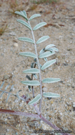
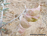
Astragalus insularis var. harwoodii
Harwood's milk-vetch
View Report Copy Link Calflora eFlora CCH CalPhotos iNaturalist

© 2012 Keir Morse |
© 2012 Keir Morse |
© 2012 Keir Morse |
Taxon Summary:
Astragalus insularis var. harwoodii, commonly known as Harwood's milk-vetch, is a annual herb in the Fabaceae that is found in California and elsewhere. It occurs within Desert dunes, and Mojavean desert scrub, growing at elevations from 0 to 710 meters. Astragalus insularis var. harwoodii is ranked 2B.2, Plants Rare, Threatened, or Endangered in California, But More Common Elsewhere; Moderately threatened in California.|
Scientific Name: Astragalus insularis Kell. var. harwoodii Munz & McBurn. |
||
|
Common Name: Harwood's milk-vetch |
||
| Family: | Fabaceae | |
| Element Code: | PDFAB0F491 | |
| USDA Plants Symbol: | ASINH | |
|
Synonyms/Other Names: |
||
| Name Status: |
JEF, FNA, POWO, IPNI, Tropicos |
|
| CA Rare Plant Rank: | 2B.2 |
| Fed List: | None |
| State List: | None |
| Global Rank: | G5T4 |
|
State Rank: |
S2 |
| Other Status: | SB_CalBG/RSABG |
|
CRPR Changes: |
|
| Add Date: | 1980-01-01 |
| Date Edited: | 2026-06-02 |
| Lifeform: annual herb | ||||||||||||||
Blooming Period: Jan-May
|
||||||||||||||
|
Elevation:
0 - 710 meters 0 - 2330 feet |
||||||||||||||
General Habitats:
|
||||||||||||||
| Microhabitat Details: | ||||||||||||||
Microhabitat:
|
||||||||||||||
| Threat List Total: | 8 | |
| Total EOs | % of EOs | |
| EOs with Threat Listed: | 89 | 74 % |
| THREAT LIST: | ||
|---|---|---|
| Development | 76 | 63% |
| ORV activity | 73 | 60% |
| Non-native plant impacts | 41 | 34% |
| Grazing | 4 | 3% |
| Road/trail construction/maint. | 3 | 2% |
| Vandalism/dumping/litter | 1 | 0% |
| Mining | 1 | 0% |
| Erosion/runoff | 1 | 0% |
| Total Occurrences: | 120 | ||||
| Element Occurrence Ranks: | |||||
|---|---|---|---|---|---|
| A | B | C | D | X | U |
| 2 | 32 | 30 | 18 | 0 | 38 |
| Occurrence Status: | |||||
|---|---|---|---|---|---|
| Historical >20 Years | 28 | ||||
| Recent <=20 Years | 92 | ||||
| Presence: | |||||
|---|---|---|---|---|---|
| Presumed Extant | 120 | ||||
| Possibly Extirpated | 0 | ||||
| Presumed Extirpated | 0 | ||||
| California Endemic: | |||||||||||||
| California Island: | |||||||||||||
|
States: Name (Code) Arizona (AZ), California (CA), Sonora, Mexico (SO) |
|||||||||||||
|
California Counties and Islands: Name (Code) Imperial (IMP), Riverside (RIV), San Bernardino (SBD), San Diego (SDG) |
|||||||||||||
|
Quads: Name (Quad Code) Grays Well NE (3211467), Agua Caliente Springs (3211683), Araz (3211476), Arica Mountains (3411418), Arroyo Tapiado (3211682), Aztec Mines (3311552), Blythe (3311455), Borrego Mountain SE (3311611), Buzzard Spring (3311575), Carrizo Mtn. (3211671), Carrizo Mtn. NE (3211681), Conejo Well (3311576), Corn Spring (3311563), Coyote Wells (3211568), Desert Center (3311564), East of Granite Pass (3411511), East of Red Canyon (3311555), East of Victory Pass (3311573), Ford Dry Lake (3311561), Harper Canyon (3311612), Hayfield Spring (3311565), Hopkins Well (3311458), In-ko-pah Gorge (3211661), Kane Spring NE (3311527), Little Maria Mts. (3311488), McCoy Peak (3311467), McCoy Spring (3311468), McCoy Wash (3311466), Ogilby (3211477), Painted Gorge (3211578), Pilot Mountain (3311553), Pinto Mountain (3311587), Placer Canyon (3311585), Red Cloud Canyon (3311554), Rice (3411417), Ripley (3311456), Roosevelt Mine (3311457), San Bernardino Wash (3311586), Sidewinder Well (3311562), Styx (3311487), Sweeney Pass (3211672), Thumb Peak (3311447), West of Palen Pass (3311582), Wister (3311535), Yuma West (3211466) |
|||||||||||||
Notes:
|
|||||||||||||
 Presumed Extant
Click on quad for name. Hold Shift Key to use mouse scroll wheel