Taxon Details
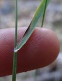
Poa sierrae
Sierra blue grass
View Report Copy Link Calflora eFlora CCH CalPhotos iNaturalist

© 2012 Belinda Lo |
© 2012 Belinda Lo |
Taxon Summary:
Poa sierrae, commonly known as Sierra blue grass, is a perennial rhizomatous herb in the Poaceae that is found only in California. It occurs within Lower montane coniferous forest, growing at elevations from 365 to 1500 meters. Poa sierrae is ranked 1B.3, Plants Rare, Threatened or Endangered in California and Elsewhere; Not very threatened in California.|
Scientific Name: Poa sierrae J.T. Howell |
||
|
Common Name: Sierra blue grass |
||
| Family: | Poaceae | |
| Element Code: | PMPOA4Z310 | |
| USDA Plants Symbol: | POSI6 | |
|
Synonyms/Other Names: |
||
| Name Status: |
JEF, FNA, POWO, IPNI, Tropicos |
|
| CA Rare Plant Rank: | 1B.3 |
| Fed List: | None |
| State List: | None |
| Global Rank: | G3 |
|
State Rank: |
S3 |
| Other Status: | BLM_S; USFS_S |
|
CRPR Changes: changed from CBR to 1B.3 on 2010-06-10 |
|
| Add Date: | 2010-06-10 |
| Date Edited: | 2025-10-29 |
| Lifeform: perennial rhizomatous herb | ||||||||||||||
Blooming Period: Apr-Jul
|
||||||||||||||
|
Elevation:
365 - 1500 meters 1200 - 4920 feet |
||||||||||||||
General Habitats:
|
||||||||||||||
| Microhabitat Details: | ||||||||||||||
Microhabitat:
|
||||||||||||||
| Threat List Total: | 15 | |
| Total EOs | % of EOs | |
| EOs with Threat Listed: | 75 | 58 % |
| THREAT LIST: | ||
|---|---|---|
| Logging | 38 | 29% |
| Road/trail construction/maint. | 32 | 24% |
| Erosion/runoff | 10 | 7% |
| Grazing | 8 | 6% |
| Improper burning regime | 7 | 5% |
| Other | 7 | 5% |
| Foot traffic/trampling | 6 | 4% |
| ORV activity | 5 | 3% |
| Wood cutting or brush clearing | 5 | 3% |
| Recreational use (non-ORV) | 4 | 3% |
| Mining | 4 | 3% |
| Non-native plant impacts | 3 | 2% |
| Biocides | 2 | 1% |
| Dam/Inundation | 1 | 0% |
| Vandalism/dumping/litter | 1 | 0% |
| Total Occurrences: | 129 | ||||
| Element Occurrence Ranks: | |||||
|---|---|---|---|---|---|
| A | B | C | D | X | U |
| 15 | 51 | 10 | 6 | 0 | 47 |
| Occurrence Status: | |||||
|---|---|---|---|---|---|
| Historical >20 Years | 10 | ||||
| Recent <=20 Years | 119 | ||||
| Presence: | |||||
|---|---|---|---|---|---|
| Presumed Extant | 129 | ||||
| Possibly Extirpated | 0 | ||||
| Presumed Extirpated | 0 | ||||
| California Endemic: | |||||||||||||
| California Island: | |||||||||||||
|
States: Name (Code) California (CA) |
|||||||||||||
|
California Counties and Islands: Name (Code) Butte (BUT), El Dorado (ELD), Nevada (NEV), Placer (PLA), Plumas (PLU), Shasta (SHA), Sierra (SIE) |
|||||||||||||
|
Quads: Name (Quad Code) Alleghany (3912047), Berry Creek (3912164), Blue Canyon (3912036), Brush Creek (3912163), Cascade (3912162), Chicago Park (3912028), Colfax (3912018), Devil Peak (3812085), Devils Rock (4012271), Dogwood Peak (3912171), Downieville (3912057), Duncan Peak (3912025), Dutch Flat (3912027), Forbestown (3912153), Foresthill (3912017), Georgetown (3812087), Greek Store (3912015), Michigan Bluff (3912016), Montgomery Creek (4012178), Pulga (3912174), Robbs Peak (3812084), Soapstone Hill (3912173), Storrie (3912183), Tunnel Hill (3812086), Washington (3912037), Westville (3912026) |
|||||||||||||
Notes:
|
|||||||||||||
 Presumed Extant
Click on quad for name. Hold Shift Key to use mouse scroll wheel