Taxon Details
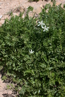
Horkelia cuneata var. puberula
mesa horkelia
View Report Copy Link Calflora eFlora CCH CalPhotos iNaturalist

© 2008 Tony Morosco |
© 2008 Tony Morosco |

© 2008 Tony Morosco |
Taxon Summary:
Horkelia cuneata var. puberula, commonly known as mesa horkelia, is a perennial herb in the Rosaceae that is found only in California. It occurs within Chaparral (maritime), Cismontane woodland, and Coastal scrub, growing at elevations from 70 to 810 meters. Horkelia cuneata var. puberula is ranked 1B.1, Plants Rare, Threatened or Endangered in California and Elsewhere; Seriously threatened in California.|
Scientific Name: Horkelia cuneata Lindl. var. puberula (Rydb.) Ertter & Reveal |
||
|
Common Name: mesa horkelia |
||
| Family: | Rosaceae | |
| Element Code: | PDROS0W045 | |
| USDA Plants Symbol: | ||
|
Synonyms/Other Names: |
||
| Name Status: |
JEF, FNA, POWO, IPNI, Tropicos |
|
| CA Rare Plant Rank: | 1B.1 |
| Fed List: | None |
| State List: | None |
| Global Rank: | G4T1 |
|
State Rank: |
S1 |
| Other Status: | BLM_S; SB_CalBG/RSABG; USFS_S |
|
CRPR Changes: |
|
| Add Date: | 2001-01-01 |
| Date Edited: | 2025-10-29 |
| Lifeform: perennial herb | ||||||||||||||
Blooming Period: Feb-Jul(Sep)
|
||||||||||||||
|
Elevation:
70 - 810 meters 230 - 2660 feet |
||||||||||||||
General Habitats:
|
||||||||||||||
| Microhabitat Details: | ||||||||||||||
Microhabitat:
|
||||||||||||||
|
Notes: Many historical occurrences extirpated; need current information on status of occurrences. Possibly threatened by habitat conversion. Intergrades with other sspp.; populations representing true ssp. puberula declining. See Pittonia 1:102 (1887) for original description, and Lloydia 1:87-88 (1938) and Novon 17(3):315-325 (2007) for revised nomenclature. |
|
|
Threats: Possibly threatened by habitat conversion. |
|
|
Taxonomy: ntergrades with other sspp.; populations representing true ssp. puberula |
|
| Threat List Total: | 7 | |
| Total EOs | % of EOs | |
| EOs with Threat Listed: | 45 | 44 % |
| THREAT LIST: | ||
|---|---|---|
| Development | 41 | 39% |
| Road/trail construction/maint. | 3 | 2% |
| Wood cutting or brush clearing | 2 | 1% |
| Mining | 2 | 1% |
| Non-native plant impacts | 1 | 0% |
| Other | 1 | 0% |
| Landfill | 1 | 0% |
| Total Occurrences: | 103 | ||||
| Element Occurrence Ranks: | |||||
|---|---|---|---|---|---|
| A | B | C | D | X | U |
| 0 | 4 | 2 | 1 | 24 | 72 |
| Occurrence Status: | |||||
|---|---|---|---|---|---|
| Historical >20 Years | 82 | ||||
| Recent <=20 Years | 21 | ||||
| Presence: | |||||
|---|---|---|---|---|---|
| Presumed Extant | 79 | ||||
| Possibly Extirpated | 14 | ||||
| Presumed Extirpated | 10 | ||||
| California Endemic: | |||||||||||||
| California Island: | |||||||||||||
|
States: Name (Code) California (CA) |
|||||||||||||
|
California Counties and Islands: Name (Code) Los Angeles (LAX), Orange (ORA), Riverside (RIV)*, San Bernardino (SBD), San Diego (SDG)*, San Luis Obispo (SLO), Santa Barbara (SBA), Ventura (VEN) |
|||||||||||||
|
Quads: Name (Quad Code) Alberhill (3311764), Arroyo Grande NE (3512025)*, Atascadero (3512046)*, Azusa (3411728)*, Baldwin Park (3411718)*, Beaumont (3311688)*, Beverly Hills (3411814)*, Black Star Canyon (3311776), Burbank (3411823)*, Cabazon (3311687), Calabasas (3411826), Cambria (3512151), Canada Gobernadora (3311755), Casmalia (3412075), Cucamonga Peak (3411725), Cypress Mountain (3512058), Devore (3411724), Dos Pueblos Canyon (3411948), El Monte (3411811)*, Fontana (3411714)*, Gaviota (3412042), Glendora (3411727)*, Goleta (3411947), Guasti (3411715), Hollywood (3411813)*, Laguna Beach (3311757), Little Pine Mtn. (3411956), Lompoc (3412064), Lompoc Hills (3412054), Los Alamos (3412063), Los Angeles (3411812)*, Manzanita Mtn. (3412081), Matilija (3411943)*, Miranda Pine Mtn. (3512011), Morro Bay South (3512037), Mt. Wilson (3411821)*, Nipomo (3512014), Oceano (3512015), Ontario (3411716), Orcutt (3412074), Pala (3311731)*, Pasadena (3411822)*, Pechanga (3311741), Pismo Beach (3512026), Pitas Point (3411934), Point Dume (3411817), Port San Luis (3512027)*, Redondo Beach (3311874), Sacate (3412043), San Bernardino South (3411713)*, San Dimas (3411717)*, San Fernando (3411834), San Luis Obispo (3512036), San Marcos Pass (3411957)*, Santa Barbara (3411946), Santa Rosa Hills (3412053), Simi (3411837), Sisquoc (3412073), Sitton Peak (3311754), Solvang (3412052), Surf (3412065), Tar Spring Ridge (3512024), Templeton (3512056)*, Tranquillon Mtn. (3412055), Triunfo Pass (3411818), Twitchell Dam (3412083), Van Nuys (3411824), Venice (3311884), Waterman Mtn. (3411738), Wheeler Springs (3411953), White Ledge Peak (3411944), Zaca Creek (3412062) |
|||||||||||||
Notes:
|
|||||||||||||
 Presumed Extant
Click on quad for name. Hold Shift Key to use mouse scroll wheel