Taxon Details
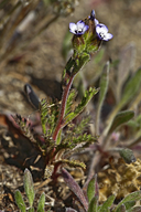
Gilia millefoliata
dark-eyed gilia
View Report Copy Link Calflora eFlora CCH CalPhotos iNaturalist

© 2017 John Doyen |
© 2015 Robert Sikora |

© 2013 Vernon Smith |
Taxon Summary:
Gilia millefoliata, commonly known as dark-eyed gilia, is a annual herb in the Polemoniaceae that is found in California and elsewhere. It occurs within Coastal dunes, growing at elevations from 2 to 30 meters. Gilia millefoliata is ranked 1B.2, Plants Rare, Threatened or Endangered in California and Elsewhere; Moderately threatened in California.|
Scientific Name: Gilia millefoliata F. & M. |
||
|
Common Name: dark-eyed gilia |
||
| Family: | Polemoniaceae | |
| Element Code: | PDPLM04130 | |
| USDA Plants Symbol: | GIMI | |
|
Synonyms/Other Names: |
||
| Name Status: |
JEF, FNA, POWO, IPNI, Tropicos |
|
| CA Rare Plant Rank: | 1B.2 |
| Fed List: | None |
| State List: | None |
| Global Rank: | G2 |
|
State Rank: |
S2 |
| Other Status: | BLM_S; SB_CalBG/RSABG |
|
CRPR Changes: |
|
| Add Date: | 2001-01-01 |
| Date Edited: | 2025-10-29 |
| Lifeform: annual herb | ||||||||||||||
Blooming Period: Apr-Jul
|
||||||||||||||
|
Elevation:
2 - 30 meters 5 - 100 feet |
||||||||||||||
General Habitats:
|
||||||||||||||
| Microhabitat Details: | ||||||||||||||
|
Microhabitat:
|
||||||||||||||
| Threat List Total: | 7 | |
| Total EOs | % of EOs | |
| EOs with Threat Listed: | 32 | 59 % |
| THREAT LIST: | ||
|---|---|---|
| Non-native plant impacts | 23 | 42% |
| ORV activity | 12 | 22% |
| Grazing | 8 | 14% |
| Development | 5 | 9% |
| Other | 3 | 5% |
| Foot traffic/trampling | 2 | 3% |
| Recreational use (non-ORV) | 1 | 1% |
| Total Occurrences: | 54 | ||||
| Element Occurrence Ranks: | |||||
|---|---|---|---|---|---|
| A | B | C | D | X | U |
| 1 | 9 | 17 | 1 | 4 | 22 |
| Occurrence Status: | |||||
|---|---|---|---|---|---|
| Historical >20 Years | 40 | ||||
| Recent <=20 Years | 14 | ||||
| Presence: | |||||
|---|---|---|---|---|---|
| Presumed Extant | 50 | ||||
| Possibly Extirpated | 2 | ||||
| Presumed Extirpated | 2 | ||||
| California Endemic: | |||||||||||||
| California Island: | |||||||||||||
|
States: Name (Code) California (CA), Oregon (OR) |
|||||||||||||
|
California Counties and Islands: Name (Code) Alameda (ALA), Contra Costa (CCA), Del Norte (DNT), Humboldt (HUM), Marin (MRN), Mendocino (MEN), San Francisco (SFO)*, San Mateo (SMT), Sonoma (SON) |
|||||||||||||
|
Quads: Name (Quad Code) Bodega Head (3812331), Bolinas (3712286), Cannibal Island (4012463), Crannell (4112411), Crescent City (4112472), Drakes Bay (3812218), Dutchmans Knoll (3912356), Eureka (4012472), Fields Landing (4012462), Fort Bragg (3912347), Hunters Point (3712263), Inglenook (3912357), Mendocino (3912337), Oakland East (3712272), Oakland West (3712273), Petrolia (4012433), Point Bonita (3712275), San Francisco North (3712274)*, San Francisco South (3712264), San Leandro (3712262), San Rafael (3712285), Sister Rocks (4112462), Smith River (4112482), Tomales (3812228), Trinidad (4112412), Tyee City (4012482) |
|||||||||||||
Notes:
|
|||||||||||||
 Presumed Extant
Click on quad for name. Hold Shift Key to use mouse scroll wheel