Taxon Details
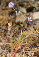
Gilia capitata ssp. pacifica
Pacific gilia
View Report Copy Link Calflora eFlora CCH CalPhotos iNaturalist

© 2016 Steve Matson |

© 2016 Steve Matson |
© 2016 Steve Matson |
Taxon Summary:
Gilia capitata ssp. pacifica, commonly known as Pacific gilia, is a annual herb in the Polemoniaceae that is found in California and elsewhere. It occurs within Chaparral (openings), Coastal bluff scrub, Coastal prairie, and Valley and foothill grassland, growing at elevations from 5 to 1665 meters. Gilia capitata ssp. pacifica is ranked 1B.2, Plants Rare, Threatened or Endangered in California and Elsewhere; Moderately threatened in California.|
Scientific Name: Gilia capitata (Jones) Heller ssp. pacifica Sims. |
||
|
Common Name: Pacific gilia |
||
| Family: | Polemoniaceae | |
| Element Code: | PDPLM040B6 | |
| USDA Plants Symbol: | GICAP | |
|
Synonyms/Other Names: |
||
| Name Status: |
JEF, FNA, POWO, IPNI, Tropicos |
|
| CA Rare Plant Rank: | 1B.2 |
| Fed List: | None |
| State List: | None |
| Global Rank: | G5T3 |
|
State Rank: |
S3 |
| Other Status: | BLM_S; SB_CalBG/RSABG |
|
CRPR Changes: |
|
| Add Date: | 2001-01-01 |
| Date Edited: | 2025-10-29 |
| Lifeform: annual herb | ||||||||||||||
Blooming Period: Apr-Aug
|
||||||||||||||
|
Elevation:
5 - 1665 meters 15 - 5465 feet |
||||||||||||||
General Habitats:
|
||||||||||||||
| Microhabitat Details: | ||||||||||||||
|
Microhabitat:
|
||||||||||||||
| Threat List Total: | 12 | |
| Total EOs | % of EOs | |
| EOs with Threat Listed: | 47 | 52 % |
| THREAT LIST: | ||
|---|---|---|
| Logging | 34 | 37% |
| Road/trail construction/maint. | 15 | 16% |
| Grazing | 10 | 10% |
| Non-native plant impacts | 9 | 9% |
| Erosion/runoff | 4 | 4% |
| Foot traffic/trampling | 3 | 3% |
| Other | 3 | 3% |
| Wood cutting or brush clearing | 2 | 2% |
| Improper burning regime | 2 | 2% |
| ORV activity | 2 | 2% |
| Mining | 2 | 2% |
| Development | 1 | 1% |
| Total Occurrences: | 91 | ||||
| Element Occurrence Ranks: | |||||
|---|---|---|---|---|---|
| A | B | C | D | X | U |
| 13 | 30 | 5 | 1 | 0 | 42 |
| Occurrence Status: | |||||
|---|---|---|---|---|---|
| Historical >20 Years | 35 | ||||
| Recent <=20 Years | 56 | ||||
| Presence: | |||||
|---|---|---|---|---|---|
| Presumed Extant | 91 | ||||
| Possibly Extirpated | 0 | ||||
| Presumed Extirpated | 0 | ||||
| California Endemic: | |||||||||||||
| California Island: | |||||||||||||
|
States: Name (Code) California (CA), Oregon (OR) |
|||||||||||||
|
California Counties and Islands: Name (Code) Del Norte (DNT), Humboldt (HUM), Mendocino (MEN), Sonoma (SON), Trinity (TRI) |
|||||||||||||
|
Quads: Name (Quad Code) Albion (3912327), Arched Rock (3812342), Bear Harbor (3912388), Board Camp Mtn. (4012366), Briceland (4012318), Bridgeville (4012347), Buckeye Mtn. (4012432), Bull Creek (4012431), Cape Mendocino (4012444), Childs Hill (4112461), Crannell (4112411), Crescent City (4112472), Dinsmore (4012345), Duncans Mills (3812341), Elk (3912326), Eureka (4012472), Ferndale (4012453), Fort Bragg (3912347), Fortuna (4012452), French Camp Ridge (4112327), Gasquet (4112378), Grouse Mtn. (4012376), Gualala (3812375), Hiouchi (4112471), Hydesville (4012451), Iaqua Buttes (4012368), Inglenook (3912357), Lord-ellis Summit (4012387), Mad River Buttes (4012367), Maple Creek (4012377), Mendocino (3912337), Myers Flat (4012337), Owl Creek (4012358), Petrolia (4012433), Point Arena (3812386), Saunders Reef (3812376), Scotia (4012441), Shelter Cove (4012411), Shubrick Peak (4012422), Sister Rocks (4112462), Smith River (4112482), Stewarts Point (3812364), Taylor Peak (4012442), Weitchpec (4112326), Weott (4012338), Westport (3912367), Willits (3912343), Yager Junction (4012357) |
|||||||||||||
Notes:
|
|||||||||||||
 Presumed Extant
Click on quad for name. Hold Shift Key to use mouse scroll wheel