Taxon Details
Leptosiphon ambiguus
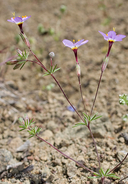
serpentine leptosiphon
View Report Copy Link Calflora eFlora CCH CalPhotos iNaturalist

© 2010 Aaron Schusteff |
© 2010 Aaron Schusteff |

© 2013 Barry Breckling |
Taxon Summary:
Leptosiphon ambiguus, commonly known as serpentine leptosiphon, is a annual herb in the Polemoniaceae that is found only in California. It occurs within Cismontane woodland, Coastal scrub, and Valley and foothill grassland, growing at elevations from 120 to 1130 meters. Leptosiphon ambiguus is ranked 4.2, Plants of Limited Distribution, A Watch List; Moderately threatened in California.|
Scientific Name: Leptosiphon ambiguus (Rattan) J.M. Porter & L.A. Johnson |
||
|
Common Name: serpentine leptosiphon |
||
| Family: | Polemoniaceae | |
| Element Code: | PDPLM09020 | |
| USDA Plants Symbol: | LEAM13 | |
|
Synonyms/Other Names: |
||
| Name Status: |
JEF, FNA, POWO, IPNI, Tropicos |
|
| CA Rare Plant Rank: | 4.2 |
| Fed List: | None |
| State List: | None |
| Global Rank: | G4 |
|
State Rank: |
S4 |
| Other Status: | SB_UCBG |
|
CRPR Changes: |
|
| Add Date: | 1994-01-01 |
| Date Edited: | 2025-10-29 |
| Lifeform: annual herb | ||||||||||||||
Blooming Period: Mar-Jun
|
||||||||||||||
|
Elevation:
120 - 1130 meters 395 - 3710 feet |
||||||||||||||
General Habitats:
|
||||||||||||||
| Microhabitat Details: | ||||||||||||||
Microhabitat:
|
||||||||||||||
| Threat List Total: | 0 | |
| Total EOs | % of EOs | |
| EOs with Threat Listed: | 0 | 0 % |
| THREAT LIST: | ||
|---|---|---|
| Total Occurrences: | 0 | ||||
| Element Occurrence Ranks: | |||||
|---|---|---|---|---|---|
| A | B | C | D | X | U |
| 0 | 0 | 0 | 0 | 0 | 0 |
| Occurrence Status: | |||||
|---|---|---|---|---|---|
| Historical >20 Years | 0 | ||||
| Recent <=20 Years | 0 | ||||
| Presence: | |||||
|---|---|---|---|---|---|
| Presumed Extant | 0 | ||||
| Possibly Extirpated | 0 | ||||
| Presumed Extirpated | 0 | ||||
| California Endemic: | |||||||||||||
| California Island: | |||||||||||||
|
States: Name (Code) California (CA) |
|||||||||||||
|
California Counties and Islands: Name (Code) Alameda (ALA), Butte (BUT), Contra Costa (CCA), El Dorado (ELD), Fresno (FRE), Merced (MER), Monterey (MNT), San Benito (SBT), San Joaquin (SJQ), San Mateo (SMT), Santa Clara (SCL), Santa Cruz (SCR), Sonoma (SON), Stanislaus (STA) |
|||||||||||||
|
Quads: Name (Quad Code) Altamont (3712166), Big Basin (3712222), Calaveras Reservoir (3712147), Cedar Mtn. (3712155), Cerro Colorado (3612068), Cherry Peak (3612162), Chittenden (3612185), Clayton (3712188), Copper Mtn. (3712143), Cupertino (3712231), Dublin (3712168), Eylar Mtn. (3712145), Gilroy (3712115), Hamlin Canyon (3912166), Hepsedam Peak (3612037), Hernandez Reservoir (3612047), Idria (3612046), Isabel Valley (3712135), La Costa Valley (3712157), Lick Observatory (3712136), Livermore (3712167), Llanada (3612058), Loma Prieta (3712117), Lone Tree Creek (3712154), Los Banos (3712017), Los Banos Valley (3612181), Los Gatos (3712128), Mendenhall Springs (3712156), Mercey Hot Springs (3612067), Morgan Hill (3712126), Mt. Boardman (3712144), Mt. Day (3712146), Mt. Madonna (3712116), Mt. Sizer (3712125), Mt. Stakes (3712134), North Chalone Peak (3612142), Ortigalita Peak (3612078), Pacheco Pass (3712112), Paicines (3612163), Palo Alto (3712242), Panoche (3612057), Panoche Pass (3612161), Paradise East (3912175), Patterson (3712142), Pilot Hill (3812171), San Benito Mtn. (3612036), San Francisco South (3712264), San Jose East (3712137), San Jose West (3712138), San Luis Dam (3712111), San Luis Ranch (3712027), San Mateo (3712253), Santa Rita Peak (3612035), Santa Teresa Hills (3712127), Solyo (3712153), Sonoma (3812234), Tassajara (3712177), Tres Pinos (3612173), Tumey Hills (3612056), Volta (3712018), Wilcox Ridge (3712133), Woodside (3712243) |
|||||||||||||
Notes:
|
|||||||||||||
 Presumed Extant
Click on quad for name. Hold Shift Key to use mouse scroll wheel