Taxon Details
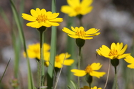
Layia septentrionalis
Colusa layia
View Report Copy Link Calflora eFlora CCH CalPhotos iNaturalist

© 2013 Jake Ruygt |

© 2020 Zoya Akulova |
© 2013 Jake Ruygt |
Taxon Summary:
Layia septentrionalis, commonly known as Colusa layia, is a annual herb in the Asteraceae that is found only in California. It occurs within Chaparral, Cismontane woodland, and Valley and foothill grassland, growing at elevations from 100 to 1095 meters. Layia septentrionalis is ranked 1B.2, Plants Rare, Threatened or Endangered in California and Elsewhere; Moderately threatened in California.|
Scientific Name: Layia septentrionalis Keck |
||
|
Common Name: Colusa layia |
||
| Family: | Asteraceae | |
| Element Code: | PDAST5N0F0 | |
| USDA Plants Symbol: | LASE2 | |
|
Synonyms/Other Names: |
||
| Name Status: |
JEF, FNA, POWO, IPNI, Tropicos |
|
| CA Rare Plant Rank: | 1B.2 |
| Fed List: | None |
| State List: | None |
| Global Rank: | G2 |
|
State Rank: |
S2 |
| Other Status: | BLM_S; SB_UCBG |
|
CRPR Changes: |
|
| Add Date: | 1994-01-01 |
| Date Edited: | 2025-10-29 |
| Lifeform: annual herb | ||||||||||||||
Blooming Period: Apr-May
|
||||||||||||||
|
Elevation:
100 - 1095 meters 330 - 3595 feet |
||||||||||||||
General Habitats:
|
||||||||||||||
| Microhabitat Details: | ||||||||||||||
Microhabitat:
|
||||||||||||||
| Threat List Total: | 7 | |
| Total EOs | % of EOs | |
| EOs with Threat Listed: | 10 | 14 % |
| THREAT LIST: | ||
|---|---|---|
| Road/trail construction/maint. | 5 | 7% |
| Development | 3 | 4% |
| Erosion/runoff | 1 | 1% |
| Grazing | 1 | 1% |
| Other | 1 | 1% |
| Agriculture | 1 | 1% |
| Biocides | 1 | 1% |
| Total Occurrences: | 69 | ||||
| Element Occurrence Ranks: | |||||
|---|---|---|---|---|---|
| A | B | C | D | X | U |
| 7 | 7 | 0 | 0 | 1 | 54 |
| Occurrence Status: | |||||
|---|---|---|---|---|---|
| Historical >20 Years | 47 | ||||
| Recent <=20 Years | 22 | ||||
| Presence: | |||||
|---|---|---|---|---|---|
| Presumed Extant | 68 | ||||
| Possibly Extirpated | 1 | ||||
| Presumed Extirpated | 0 | ||||
| California Endemic: | |||||||||||||
| California Island: | |||||||||||||
|
States: Name (Code) California (CA) |
|||||||||||||
|
California Counties and Islands: Name (Code) Butte (BUT), Colusa (COL), Glenn (GLE), Lake (LAK), Mendocino (MEN), Napa (NAP), Sonoma (SON), Sutter (SUT), Tehama (TEH), Yolo (YOL) |
|||||||||||||
|
Quads: Name (Quad Code) Aetna Springs (3812264), Arbuckle (3912211), Benmore Canyon (3912215), Cherokee (3912165), Chiles Valley (3812253), Cloverdale (3812371), Detert Reservoir (3812265), Dunnigan (3812188), Elk Creek (3912255), Gilmore Peak (3912235), Glascock Mtn. (3812283), Grimes (3912118), Highland Springs (3812288), Hopland (3812381), Jericho Valley (3812274), Kelseyville (3812287), Kenwood (3812245)*, Knoxville (3812273), Lakeport (3912218), Leesville (3912224), Lower Lake (3812285), Lucerne (3912217), Monticello Dam (3812251), Paskenta (3912285), Purdys Gardens (3912311), Rail Canyon (3912244), Riley Ridge (3912286), Rumsey (3812282), Santa Rosa (3812246), St. Helena (3812254), Stonyford (3912245), Sutter Buttes (3912127), The Geysers (3812277), Walter Springs (3812263), Whispering Pines (3812276), Wilbur Springs (3912214), Wildwood School (3812281), Wilson Valley (3812284) |
|||||||||||||
Notes:
|
|||||||||||||
 Presumed Extant
Click on quad for name. Hold Shift Key to use mouse scroll wheel