Taxon Details
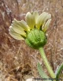
Layia heterotricha
pale-yellow layia
View Report Copy Link Calflora eFlora CCH CalPhotos iNaturalist

© 2003 Christopher L. Christie |
© 2015 Keir Morse |
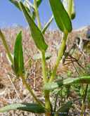
© 2015 Keir Morse |
Taxon Summary:
Layia heterotricha, commonly known as pale-yellow layia, is a annual herb in the Asteraceae that is found only in California. It occurs within Cismontane woodland, Coastal scrub, Pinyon and juniper woodland, and Valley and foothill grassland, growing at elevations from 300 to 1705 meters. Layia heterotricha is ranked 1B.1, Plants Rare, Threatened or Endangered in California and Elsewhere; Seriously threatened in California.|
Scientific Name: Layia heterotricha (DC.) H. & A. |
||
|
Common Name: pale-yellow layia |
||
| Family: | Asteraceae | |
| Element Code: | PDAST5N070 | |
| USDA Plants Symbol: | LAHE | |
|
Synonyms/Other Names: |
||
| Name Status: |
JEF, FNA, POWO, IPNI, Tropicos |
|
| CA Rare Plant Rank: | 1B.1 |
| Fed List: | None |
| State List: | None |
| Global Rank: | G2 |
|
State Rank: |
S2 |
| Other Status: | BLM_S; SB_CalBG/RSABG; SB_SBBG; USFS_S |
|
CRPR Changes: |
|
| Add Date: | 1994-01-01 |
| Date Edited: | 2025-10-29 |
| Lifeform: annual herb | ||||||||||||||
Blooming Period: Mar-Jun
|
||||||||||||||
|
Elevation:
300 - 1705 meters 985 - 5595 feet |
||||||||||||||
General Habitats:
|
||||||||||||||
| Microhabitat Details: | ||||||||||||||
Microhabitat:
|
||||||||||||||
| Threat List Total: | 11 | |
| Total EOs | % of EOs | |
| EOs with Threat Listed: | 33 | 26 % |
| THREAT LIST: | ||
|---|---|---|
| Non-native plant impacts | 11 | 8% |
| Road/trail construction/maint. | 11 | 8% |
| Development | 7 | 5% |
| Grazing | 6 | 4% |
| ORV activity | 5 | 4% |
| Feral pigs | 3 | 2% |
| Foot traffic/trampling | 2 | 1% |
| Erosion/runoff | 2 | 1% |
| Improper burning regime | 2 | 1% |
| Other | 1 | 0% |
| Agriculture | 1 | 0% |
| Total Occurrences: | 125 | ||||
| Element Occurrence Ranks: | |||||
|---|---|---|---|---|---|
| A | B | C | D | X | U |
| 21 | 12 | 1 | 8 | 1 | 82 |
| Occurrence Status: | |||||
|---|---|---|---|---|---|
| Historical >20 Years | 61 | ||||
| Recent <=20 Years | 64 | ||||
| Presence: | |||||
|---|---|---|---|---|---|
| Presumed Extant | 124 | ||||
| Possibly Extirpated | 0 | ||||
| Presumed Extirpated | 1 | ||||
| California Endemic: | |||||||||||||
| California Island: | |||||||||||||
|
States: Name (Code) California (CA) |
|||||||||||||
|
California Counties and Islands: Name (Code) Fresno (FRE), Kern (KRN)*, Kings (KNG)*, Monterey (MNT), San Benito (SBT)(?), San Luis Obispo (SLO)*, Santa Barbara (SBA), Ventura (VEN) |
|||||||||||||
|
Quads: Name (Quad Code) Apache Canyon (3411973), Ballinger Canyon (3411984), Bates Canyon (3411988), Bear Canyon (3612113), Bryson (3512171), Burnett Peak (3512172), Caliente Mtn. (3511917), California Valley (3512031)*, Camatta Ranch (3512043), Carneros Rocks (3511947)*, Casmalia (3412075), Chimineas Ranch (3511928), Cholame (3512063), Cholame Valley (3512073), Ciervo Mtn. (3612045), Coalinga (3612023)*, Cuddy Valley (3411971), Curry Mountain (3612014)*, Cuyama (3411985), Cuyama Peak (3411974), Domengine Ranch (3612033), Elkhorn Hills (3511915)*, Fox Mountain (3411975), Freeman Junction (3511758), Garza Peak (3512082)*, Goleta (3411947), Greenfield (3612132), Hames Valley (3512088)*, Joaquin Rocks (3612034), La Panza (3512032)*, Lake Cachuma (3411958), Las Yeguas Ranch (3511948)*, Lillis Ranch (3612044), Lockwood Valley (3411961), Lompoc (3412064), Matilija (3411943), McKittrick Summit (3511937), Mojave (3511812)*, Monarch Peak (3612027), Monolith (3511813)*, Nattrass Valley (3612028), North Chalone Peak (3612142), Orchard Peak (3512062)*, Panoche (3612057)(?), Panorama Hills (3511926), Pleito Hills (3411981), Rancho Nuevo Creek (3411964), Reward (3511936), Reyes Peak (3411963), Rock Spring Peak (3612048), Salisbury Potrero (3411976), San Guillermo (3411962), Santa Rita Peak (3612035), Sawmill Mountain (3411972)*, Simmler (3511938), Smith Mountain (3612015), Surf (3412065), Taylor Canyon (3511918), Tehachapi NE (3511823)*, Tehachapi North (3511824), Tehachapi South (3511814), Tent Hills (3512072), The Dark Hole (3512083), Thompson Canyon (3612122)*, Tierra Redonda Mountain (3512078)*, Tumey Hills (3612056), Wells Ranch (3511916), Wheeler Springs (3411953)*, Wilson Corner (3512044) |
|||||||||||||
Notes:
|
|||||||||||||
 Presumed Extant
Click on quad for name. Hold Shift Key to use mouse scroll wheel