Taxon Details
Carex limosa
mud sedge
View Report Copy Link Calflora eFlora CCH CalPhotos iNaturalist
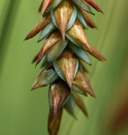
Steve Matson 2009 |

Steve Matson 2009 |
Dean Wm. Taylor 2017 |
Taxon Summary:
Carex limosa, commonly known as mud sedge, is a perennial rhizomatous herb in the Cyperaceae that is found in California and elsewhere. It occurs within Bogs and fens, Lower montane coniferous forest, Marshes and swamps, Meadows and seeps, and Upper montane coniferous forest, growing at elevations from 1200 to 2700 meters. Carex limosa is ranked 2B.2, Plants Rare, Threatened, or Endangered in California, But More Common Elsewhere; Moderately threatened in California.|
Scientific Name: Carex limosa L. |
||
|
Common Name: mud sedge |
||
| Family: | Cyperaceae | |
| Element Code: | PMCYP037K0 | |
| USDA Plants Symbol: | CALI7 | |
|
Synonyms/Other Names: |
||
| Name Status: |
JEF, FNA, POWO, IPNI, Tropicos |
|
| CA Rare Plant Rank: | 2B.2 |
| Fed List: | None |
| State List: | None |
| Global Rank: | G5 |
|
State Rank: |
S3 |
| Other Status: | IUCN_LC |
|
CRPR Changes: |
|
| Add Date: | 1994-01-01 |
| Date Edited: | 2025-10-29 |
| Lifeform: perennial rhizomatous herb | ||||||||||||||
Blooming Period: Jun-Aug
|
||||||||||||||
|
Elevation:
1200 - 2700 meters 3935 - 8860 feet |
||||||||||||||
General Habitats:
|
||||||||||||||
| Microhabitat Details: | ||||||||||||||
|
Microhabitat:
|
||||||||||||||
|
Notes: Possibly more widespread in the Sierra Nevada. Threatened by grazing and vehicles. Potentially threatened by logging. Similar to C. buxbaumii. |
|
|
Threats: |
|
|
Taxonomy: |
|
| Threat List Total: | 7 | |
| Total EOs | % of EOs | |
| EOs with Threat Listed: | 11 | 28 % |
| THREAT LIST: | ||
|---|---|---|
| Foot traffic/trampling | 5 | 12% |
| Grazing | 5 | 12% |
| Logging | 3 | 7% |
| ORV activity | 3 | 7% |
| Altered flood/tidal/hydrologic regime | 2 | 5% |
| Other | 1 | 2% |
| Recreational use (non-ORV) | 1 | 2% |
| Total Occurrences: | 40 | ||||
| Element Occurrence Ranks: | |||||
|---|---|---|---|---|---|
| A | B | C | D | X | U |
| 9 | 5 | 0 | 2 | 0 | 24 |
| Occurrence Status: | |||||
|---|---|---|---|---|---|
| Historical >20 Years | 27 | ||||
| Recent <=20 Years | 13 | ||||
| Presence: | |||||
|---|---|---|---|---|---|
| Presumed Extant | 40 | ||||
| Possibly Extirpated | 0 | ||||
| Presumed Extirpated | 0 | ||||
| California Endemic: | |||||||||||||
| California Island: | |||||||||||||
|
States: Name (Code) Alaska (AK), California (CA), Colorado (CO), Connecticut (CT), Delaware (DE)*, Idaho (ID), Illinois (IL), Indiana (IN), Iowa (IA), Maine (ME), Massachusetts (MA), Michigan (MI), Minnesota (MN), Montana (MT), Nebraska (NE), Nevada (NV), New Hampshire (NH), New Jersey (NJ), New Mexico (NM), New York (NY), North Dakota (ND), Ohio (OH), Oregon (OR), Pennsylvania (PA), Rhode Island (RI)*, Utah (UT), Vermont (VT), Washington (WA), Wisconsin (WI), Wyoming (WY) |
|||||||||||||
|
California Counties and Islands: Name (Code) Butte (BUT), El Dorado (ELD), Fresno (FRE), Lassen (LAS), Mariposa (MPA), Nevada (NEV), Plumas (PLU), Siskiyou (SIS), Tehama (TEH), Tuolumne (TUO) |
|||||||||||||
|
Quads: Name (Quad Code) Ackerson Mtn. (3711977), Almanor (4012122), Belden (4012113), Bucks Lake (3912182), Butte Meadows (4012115), Cherry Lake North (3811918), Cisco Grove (3912035), Cooper Peak (3811927), Dogtooth Peak (3711921), Dogwood Peak (3912171), Echo Lake (3812071), Freel Peak (3811978), Hobart Mills (3912042), Humboldt Peak (4012124), Humbug Valley (4012123), Huntington Lake (3711922), Independence Lake (3912043), Jess Valley (4112023), Jonesville (4012114), Kyburz (3812073), Lake Eleanor (3711987), Loon Lake (3812083), Mariposa Grove (3711955), Meeks Bay (3912011), Mt. Harkness (4012143), Pinecrest (3811928), Reading Peak (4012144), Red Cinder (4012142), Seven Lakes Basin (4112224) |
|||||||||||||
Notes:
|
|||||||||||||
 Presumed Extant
Click on quad for name. Hold Shift Key to use mouse scroll wheel