Taxon Details
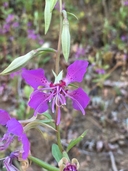
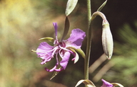
Clarkia borealis ssp. borealis
northern clarkia
View Report Copy Link Calflora eFlora CCH CalPhotos iNaturalist
©2018 Sierra Pacific Industries |
©2002 Martin J. Lenz |

©2016 Sierra Pacific Industries |
Taxon Summary:
Clarkia borealis ssp. borealis, commonly known as northern clarkia, is a annual herb in the Onagraceae that is found only in California. It occurs within Chaparral, Cismontane woodland, and Lower montane coniferous forest, growing at elevations from 400 to 1565 meters. Clarkia borealis ssp. borealis is ranked 4.3, Plants of Limited Distribution, A Watch List; Not very threatened in California.|
Scientific Name: Clarkia borealis E. Small ssp. borealis |
||
|
Common Name: northern clarkia |
||
| Family: | Onagraceae | |
| Element Code: | PDONA05062 | |
| USDA Plants Symbol: | CLBOB | |
|
Synonyms/Other Names: |
||
| Name Status: |
JEF, FNA, POWO, IPNI, Tropicos |
|
| CA Rare Plant Rank: | 4.3 |
| Fed List: | None |
| State List: | None |
| Global Rank: | G3T4 |
|
State Rank: |
S4 |
| Other Status: | SB_UCSC; USFS_S |
|
CRPR Changes: changed from 1B.3 to 4.3 on 2020-03-16 |
|
| Add Date: | 1980-01-01 |
| Date Edited: | 2025-10-29 |
| Lifeform: annual herb | ||||||||||||||
Blooming Period: Jun-Sep
|
||||||||||||||
|
Elevation:
400 - 1565 meters 1310 - 5135 feet |
||||||||||||||
General Habitats:
|
||||||||||||||
| Microhabitat Details: often roadcuts | ||||||||||||||
Microhabitat:
|
||||||||||||||
| Threat List Total: | 12 | |
| Total EOs | % of EOs | |
| EOs with Threat Listed: | 103 | 79 % |
| THREAT LIST: | ||
|---|---|---|
| Logging | 80 | 61% |
| Road/trail construction/maint. | 50 | 38% |
| Other | 9 | 6% |
| Non-native plant impacts | 6 | 4% |
| Erosion/runoff | 5 | 3% |
| Biocides | 4 | 3% |
| ORV activity | 2 | 1% |
| Recreational use (non-ORV) | 1 | 0% |
| Altered flood/tidal/hydrologic regime | 1 | 0% |
| Foot traffic/trampling | 1 | 0% |
| Improper burning regime | 1 | 0% |
| Wood cutting or brush clearing | 1 | 0% |
| Total Occurrences: | 131 | ||||
| Element Occurrence Ranks: | |||||
|---|---|---|---|---|---|
| A | B | C | D | X | U |
| 16 | 75 | 16 | 0 | 0 | 24 |
| Occurrence Status: | |||||
|---|---|---|---|---|---|
| Historical >20 Years | 15 | ||||
| Recent <=20 Years | 116 | ||||
| Presence: | |||||
|---|---|---|---|---|---|
| Presumed Extant | 131 | ||||
| Possibly Extirpated | 0 | ||||
| Presumed Extirpated | 0 | ||||
| California Endemic: | |||||||||||||
| California Island: | |||||||||||||
|
States: Name (Code) California (CA) |
|||||||||||||
|
California Counties and Islands: Name (Code) Shasta (SHA), Trinity (TRI) |
|||||||||||||
|
Quads: Name (Quad Code) Big Bend (4112118), Bohemotash Mtn. (4012274), Bollibokka Mtn. (4012282), Chalk Mtn. (4012187), Chicken Hawk Hill (4112214), Damnation Peak (4012285), Devils Rock (4012271), Goose Gap (4012281), Hanland Peak (4012283), Lamoine (4012284), Miller Mtn. (4012167), Minnesota Mtn. (4012272), Montgomery Creek (4012178), O'Brien (4012273), Papoose Creek (4012276), Project City (4012263), Roaring Creek (4012188), Schell Mtn. (4012275), Shasta Dam (4012264), Shoeinhorse Mtn. (4112211), Skunk Ridge (4112117), Tombstone Mtn. (4112213), Trinity Center (4012286), Whitmore (4012168), Yellowjacket Mtn. (4112212) |
|||||||||||||
Notes:
|
|||||||||||||
 Presumed Extant
Click on quad for name. Hold Shift Key to use mouse scroll wheel