Taxon Details
Allium sanbornii var. sanbornii
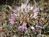
Sanborn's onion
View Report Copy Link Calflora eFlora CCH CalPhotos iNaturalist
©2018 Steven Perry |

©2006 Dean Wm. Taylor, Ph.D. |

©2018 Steven Perry |
Taxon Summary:
Allium sanbornii var. sanbornii, commonly known as Sanborn's onion, is a perennial bulbiferous herb in the Alliaceae that is found in California and elsewhere. It occurs within Chaparral, Cismontane woodland, and Lower montane coniferous forest, growing at elevations from 260 to 1510 meters. Allium sanbornii var. sanbornii is ranked 4.2, Plants of Limited Distribution, A Watch List; Moderately threatened in California.|
Scientific Name: Allium sanbornii A.W. Wood var. sanbornii |
||
|
Common Name: Sanborn's onion |
||
| Family: | Alliaceae | |
| Element Code: | PMLIL02212 | |
| USDA Plants Symbol: | ALSAS | |
|
Synonyms/Other Names: |
||
| Name Status: |
JEF, FNA, POWO, IPNI, Tropicos |
|
| CA Rare Plant Rank: | 4.2 |
| Fed List: | None |
| State List: | None |
| Global Rank: | G3T4? |
|
State Rank: |
S3S4 |
| Other Status: | |
|
CRPR Changes: |
|
| Add Date: | 1994-01-01 |
| Date Edited: | 2025-10-29 |
| Lifeform: perennial bulbiferous herb | ||||||||||||||
Blooming Period: May-Sep
|
||||||||||||||
|
Elevation:
260 - 1510 meters 855 - 4955 feet |
||||||||||||||
General Habitats:
|
||||||||||||||
| Microhabitat Details: | ||||||||||||||
Microhabitat:
|
||||||||||||||
| Threat List Total: | 0 | |
| Total EOs | % of EOs | |
| EOs with Threat Listed: | 0 | 0 % |
| THREAT LIST: | ||
|---|---|---|
| Total Occurrences: | 0 | ||||
| Element Occurrence Ranks: | |||||
|---|---|---|---|---|---|
| A | B | C | D | X | U |
| 0 | 0 | 0 | 0 | 0 | 0 |
| Occurrence Status: | |||||
|---|---|---|---|---|---|
| Historical >20 Years | 0 | ||||
| Recent <=20 Years | 0 | ||||
| Presence: | |||||
|---|---|---|---|---|---|
| Presumed Extant | 0 | ||||
| Possibly Extirpated | 0 | ||||
| Presumed Extirpated | 0 | ||||
| California Endemic: | |||||||||||||
| California Island: | |||||||||||||
|
States: Name (Code) California (CA), Oregon (OR) |
|||||||||||||
|
California Counties and Islands: Name (Code) Butte (BUT), Calaveras (CAL), El Dorado (ELD), Nevada (NEV), Placer (PLA), Shasta (SHA), Tehama (TEH), Tuolumne (TUO), Yuba (YUB) |
|||||||||||||
|
Quads: Name (Quad Code) Barkley Mtn. (4012126), Berry Creek (3912164), Bollibokka Mtn. (4012282), Brush Creek (3912163), Butte Meadows (4012115), Challenge (3912142), Cherry Lake South (3711988), Chicago Park (3912028), Clipper Mills (3912152), Cohasset (3912186), Colfax (3912018), Devil Peak (3812085), Devils Nose (3812044), Devils Parade Ground (4012116), Dorrington (3812033), Dutch Flat (3912027), Finley Butte (4012137), Forbestown (3912153), Foresthill (3912017), Fort Mountain (3812034), French Corral (3912132), Garnet Hill (3812043), Grass Valley (3912121), Greek Store (3912015), Hagaman Gulch (4012157), Hatchet Mtn. Pass (4012177), Igo (4012255), Inskip Hill (4012138), Lyonsville (4012136), Manton (4012147), Michigan Bluff (3912016), Miller Mtn. (4012167), Minnesota Mtn. (4012272), Montgomery Creek (4012178), Murphys (3812024), Nevada City (3912131), Omo Ranch (3812055), Onion Butte (4012125), Panther Spring (4012127), Paradise East (3912175), Pilot Hill (3812171), Rackerby (3912143), Roaring Creek (4012188), Rough And Ready (3912122), Shasta Dam (4012264), Shingle Springs (3812068), Stirling City (3912185), Washington (3912037), Westville (3912026), Whitmore (4012168) |
|||||||||||||
Notes:
|
|||||||||||||
 Presumed Extant
Click on quad for name. Hold Shift Key to use mouse scroll wheel