Taxon Details
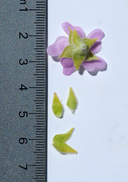
Malacothamnus aboriginum
Indian Valley bushmallow
View Report Copy Link Calflora eFlora CCH CalPhotos iNaturalist

© 2009 Keir Morse |
© 2011 Chris Winchell |

© 2017 Keir Morse |
Taxon Summary:
Malacothamnus aboriginum, commonly known as Indian Valley bushmallow, is a perennial deciduous shrub in the Malvaceae that is found only in California. It occurs within Chaparral, and Cismontane woodland, growing at elevations from 150 to 1700 meters. Malacothamnus aboriginum is ranked 1B.2, Plants Rare, Threatened or Endangered in California and Elsewhere; Moderately threatened in California.|
Scientific Name: Malacothamnus aboriginum (Rob.) Greene |
||
|
Common Name: Indian Valley bushmallow |
||
| Family: | Malvaceae | |
| Element Code: | PDMAL0Q020 | |
| USDA Plants Symbol: | MAAB2 | |
|
Synonyms/Other Names: |
||
| Name Status: |
JEF, FNA, POWO, IPNI, Tropicos |
|
| CA Rare Plant Rank: | 1B.2 |
| Fed List: | None |
| State List: | None |
| Global Rank: | G3 |
|
State Rank: |
S3 |
| Other Status: | BLM_S; SB_CalBG/RSABG; SB_SBBG |
|
CRPR Changes: |
|
| Add Date: | 1974-01-01 |
| Date Edited: | 2025-10-29 |
| Lifeform: perennial deciduous shrub | ||||||||||||||
Blooming Period: Apr-Oct
|
||||||||||||||
|
Elevation:
150 - 1700 meters 490 - 5580 feet |
||||||||||||||
General Habitats:
|
||||||||||||||
| Microhabitat Details: | ||||||||||||||
Microhabitat:
|
||||||||||||||
| Threat List Total: | 6 | |
| Total EOs | % of EOs | |
| EOs with Threat Listed: | 8 | 13 % |
| THREAT LIST: | ||
|---|---|---|
| Grazing | 4 | 6% |
| Road/trail construction/maint. | 3 | 4% |
| Biocides | 1 | 1% |
| Mining | 1 | 1% |
| Non-native plant impacts | 1 | 1% |
| ORV activity | 1 | 1% |
| Total Occurrences: | 63 | ||||
| Element Occurrence Ranks: | |||||
|---|---|---|---|---|---|
| A | B | C | D | X | U |
| 0 | 2 | 2 | 3 | 0 | 56 |
| Occurrence Status: | |||||
|---|---|---|---|---|---|
| Historical >20 Years | 38 | ||||
| Recent <=20 Years | 25 | ||||
| Presence: | |||||
|---|---|---|---|---|---|
| Presumed Extant | 63 | ||||
| Possibly Extirpated | 0 | ||||
| Presumed Extirpated | 0 | ||||
| California Endemic: | |||||||||||||
| California Island: | |||||||||||||
|
States: Name (Code) California (CA) |
|||||||||||||
|
California Counties and Islands: Name (Code) Fresno (FRE), Kings (KNG), Monterey (MNT), San Benito (SBT) |
|||||||||||||
|
Quads: Name (Quad Code) Alcalde Hills (3612024), Bickmore Canyon (3612152), Cherry Peak (3612162), Ciervo Mtn. (3612045), Curry Mountain (3612014), Garza Peak (3512082), Gonzales (3612154), Hepsedam Peak (3612037), Hernandez Reservoir (3612047), Hollister (3612174), Idria (3612046), Joaquin Rocks (3612034), Llanada (3612058), Lonoak (3612038), North Chalone Peak (3612142), Paicines (3612163)?, Panoche Pass (3612161), Pinalito Canyon (3612131), Rock Spring Peak (3612048), San Benito (3612151), San Benito Mtn. (3612036), Santa Rita Peak (3612035), Smith Mountain (3612015), Soledad (3612143), Stockdale Mountain (3512085), The Dark Hole (3512083), Topo Valley (3612141), Tres Pecos Farms (3612043), Tres Pinos (3612173), Valleton (3512086) |
|||||||||||||
Notes:
|
|||||||||||||
 Presumed Extant
Click on quad for name. Hold Shift Key to use mouse scroll wheel